

LOUISVILLE, Ky. (WDRB) -- A possible ice storm is in the forecast for Louisville, southern Indiana and parts of Kentucky later this week.
Preparations are underway for a one-two punch as the area faces the real possibility of freezing rain moving in Thursday evening followed by bitter cold.
The Federal Emergency Management Agency is telling people to get ready by stocking up on supplies to make sure you can stay home for several days, possibly without power. It suggests you have enough food, batteries and medicine to at least get you through the weekend.
People with smartphones, cellphones and other electronics should make sure they are fully charged in case you lose power.
Limit your time outside, but if you need to go outside, make sure to dress in layers. Watch for signs of frostbite or hypothermia. When it is safe, check on your neighbors or friends nearby who may need assistance.
FEMA said try to avoid travel, but if you must go out, listen to local media for the latest road conditions and closures. Also, make sure you have a full tank of gas, an emergency supply kit, food, water and blankets in your car.
Do not forget the needs of pets. If possible, bring pets indoors. But if animals must stay outside, make sure there is a warm shelter with extra insulation or blankets. Make sure water bowls don't freeze.
Pay attention to local media for updates on air or on social media about emergency services.
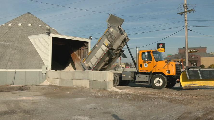
Louisville Metro Public Works has 111 snow routes and takes care of more than 5,000 miles of roadway. According to Salvador Melendez with Metro Public Works, road crews are on standby and teams will be monitoring the weather, ready to start treating as soon as possible. He said there are enough crews to work.
"We could have different amounts of rain or wintery mix — whatever is coming down — falling in different parts of the county," Melendez said.
He said with rain expected first, pre-treating with liquid brine is not an option. Instead, Melendez said crews will have to wait until the rain comes to treat roads with salt.
"Brine pre-treatment is out of the question simply because it would get washed away," he said. "The ideal time is when there's just moisture on the surface for that salt to stick and stay in place."
Melendez said major roadways like Dixie Highway, Hurstbourne Parkway and Taylorsville Road will be treated immediately. He said warmer weather Tuesday is working in road crews' favor, because that means even if the air temperature drops below freezing, the roads temperatures may not drop as quickly.
"Hopefully it remains warm enough before anything freezing starts coming down and it doesn't immediately freeze on contact," he said. "That's what we're hoping for."
Jason Baird, manager at Big O Tires in New Albany, said people can do things now to try and get their cars ready for winter weather.
"If it is really bad and you guys don't have to drive, please don't," Baird said. "But if you have to, we want you to do everything you can to stay safe."
He said to check the tire pressure and tread, make sure wiper fluid is topped off. And if there is ice or snow, clean off headlights and tail-lights to help with visibility.
"You do see a lot of slide-offs and a lot of bent rims, things of that nature, when you've had bad weather like we've had," he said.
Baird also suggests keeping deicer and ice scrapers inside the house and not inside the car, because if the car doors or locks get covered in ice, it could be difficult to get into the vehicle to get to the deicer or scraper.
INDOT, KYTC and Louisville Public Works will continue monitoring driving conditions as rain and freezing rain fall on Thursday into Friday.

INDOT Southeast crews unload salt ahead of Thursday's storm.
The most common threat for power outages is trees limbs falling onto power lines or other parts of the system.
As little as a quarter of an inch of ice can cause that to happen.
For the Louisville area, LG&E and KU said it has 600 employees to address any power outages. And it has mutual partners from about 20 different states on standby if the storm has a more large-scale impact.
Joe Arnold with Kentucky Electric Cooperatives shared a similar game plan as it prepares.
"Ice storms in particular, are sort of a perpetuating disaster. Because the ice is on the limbs and on the trees. It's bringing you down some and even as you're restoring power. Other tree limbs that could have been compromised or weakened and still have ice weighing them down could still continue to fall, even a day or two later," Arnold said.
In southern Indiana, Duke Energy said it has called in an extra 300 response crews from out of state for extra support.
If there's some wet snow in the wintery mix, Duke Energy said about six inches is the marker for snow involved power issues.
If you experience a power outage, remember linemen and other crews working to restore power can only do so if travel conditions are safe for them to get to your neighborhood.
"We're going to do what we can to restore power as quickly and as safely as we can. And just for customers to remember that we're out there to help them just be patient and take those extra precautions," Lisa Huber with Duke Energy said. "We'll get through this together and we appreciate their patience."
If you see a downed power line, assume it's live. Don't touch it and call the appropriate utility company.
Other tips for power outage preparedness include knowing where your blankets are to stay warm, having batteries for any flashlights and never use a gas stove or oven to heat your home.
For the latest updates in Indiana, click here.
For the latest from KYTC, click here.
For the latest conditions and closures from TRIMARC, click here.
Louisville's "snow team" updates its progress on a map of its snow routes. click here.
To check the latest forecast from our team of WDRB meteorologists, just go to our weather page.
Winter is a great time to download the WDRB Weather app for your Apple or Android phone. It allows you to check current conditions, local radar and get the hour-by-hour forecast. To find out how to download, click here.
Copyright 2022 WDRB Media. All Rights Reserved.


