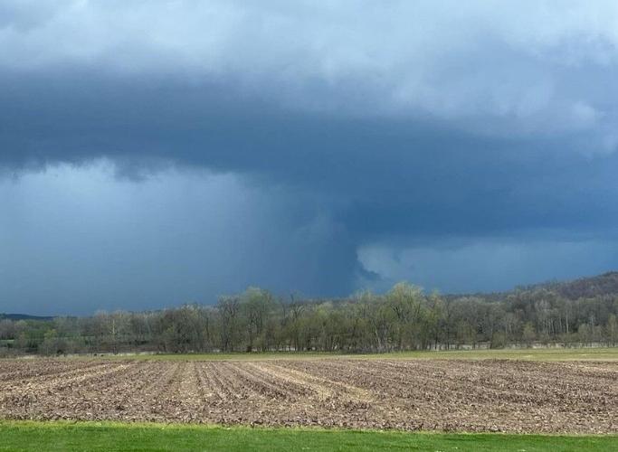


LOUISVILLE, Ky. (WDRB) -- A tornado that touched down in Oldham County on April 2 has been upgraded to an EF-2.
The National Weather Service said Friday that its survey found damage from 115 mile per hour winds in Buckner.
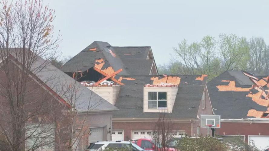
The survey teams continued work days after Tuesday's line of storms that left damage in 13 Kentucky counties and another four counties in Indiana.
An EF-2 tornado was also confirmed in Prospect with 120 mile per hour winds in the Beachland Beach area.
Tornadoes, strong winds and heavy rain moved through Kentuckiana Tuesday evening, leaving scattered sheds, furniture and other debris across the area.
Straight line wind damage was confirmed in multiple counties including Fayette, Woodford, Mercer and Spencer counties in Kentucky and in Crawford county in Indiana.
Tornadoes are rated on the Enhanced Fujita Scale or EF Scale based on wind speeds and related damage. The scale is based on a three-second gust of wind at the point of damage based on set factors. A rating of EF-0 to EF-5 is assigned to a tornado by National Weather Service surveyors.
EF Scale (3 Second Gust MPH)
| EF-0 | 65 to 85 mph |
| EF-1 | 86-110 mph |
| EF-2 | 111-135 mph |
| EF-3 | 136-165 mph |
| EF-4 | 166-200 mph |
| EF-5 | Over 200 mph |
As of Friday morning, the National Weather Service confirmed tornadoes from April 2 in the following locations:
Kentucky
- Jefferson: EF-2 with 120 mph winds
- Oldham: EF-2 with 115 mph winds (Buckner)
- Oldham: EF-1 with 95 mph
- Henry: EF-1 with 110 mph winds
- Bourbon/Clark: EF-1 with 105 mph winds
- Jessamine: EF-1 with 110 mph winds
- Anderson: EF-1 with 95 mph winds
- Nelson: EF-1 with 95 mph winds
Indiana
- Harrison/Floyd: EF-1 with 95 mph (survey continues)
- Clark: EF-1 with 100 mph winds
More Severe Weather Coverage:
- National Weather Service upgrades tornado in Prospect to an EF2
- 'Pretty incredible' | Beshear, Greenberg praise community response after severe storms in Louisville
- Tornadoes, straight line wind damage in Kentuckiana confirmed by National Weather Service
- Possible tornado moves through Louisville area, damaging homes in southern Indiana, Oldham County
- Residents survey damage after possible tornado moves through Jeffersonville, Indiana Tuesday evening
- VIDEO | Dash camera footage shows possible tornado near Utica, Indiana
- EF-1 tornado confirmed in Nelson County, state of emergency declared in Kentucky
- It's storm season in Kentuckiana: Here's what to know to stay prepared
- Tornado and hail leave extensive damage in multiple Kentucky, Indiana counties
- 'I feel real lucky' | Kentucky, Indiana residents picking up the pieces after being hit by tornado, hail
Copyright 2024 WDRB Media. All Rights Reserved.


