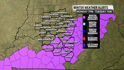

LOUISVILLE, Ky. (WDRB) -- Parts of the WDRB viewing area could see some winter weather Monday night into Tuesday morning, especially areas south of Louisville. Here's the updated winter weather advisory from the National Weather Service.
WINTER WEATHER ADVISORY IN EFFECT FROM 7 PM EST /6 PM CST/
THIS EVENING TO 7 AM EST /6 AM CST/ TUESDAY...
WHAT...Rain is expected to quickly change over to a brief period of wet snow. The snow could be heavy at times. Many areas within the advisory will see less than 1 inch of snowfall; however, localized amounts of 1 to 3 inches of snow are possible.
WHERE...Portions of south central Kentucky.
WHEN...From 7 PM EST /6 PM CST/ Monday to 7 AM EST /6 AM CST/ Tuesday.
IMPACTS...Plan on slippery road conditions. The hazardous conditions could impact the Tuesday morning commute.
ADDITIONAL DETAILS...It is likely that a narrow band of heavy snow will develop with this system. At this time, it is very difficult to determine where this band may set up. This advisory highlights the areas at most risk for impactful snow and subsequent changes in the forecast may be required.
Stay tuned for future forecast updates.
Copyright 2024 WDRB Media. All Rights Reserved.


