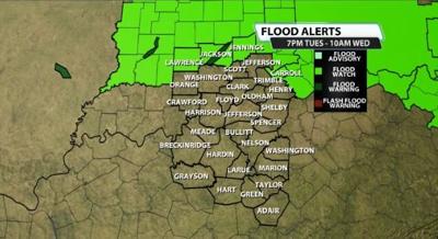

With more rain and storms expected overnight, especially in Indiana, the NWS in Indianapolis and NWS in Cincinnati have issued a Flood Watch for the counties in our viewing area that they cover. This does NOT include Louisville. It is in effect from 7PM this evening through 10AM Wednesday morning.

This is due to that warm front that moved through today stalling in southern Indiana and allowing for multiple rounds of rain and perhaps some storms to roll through overnight tonight. Jackson, Jennings, Lawrence, and Carroll counties are included.
Here's more on the watch from the NWS:
* WHEN...From 7 PM EST this evening through Wednesday morning.
* IMPACTS...Excessive runoff may result in flooding of rivers,
creeks, streams, and other low-lying and flood-prone locations.
Creeks and streams may rise out of their banks.
* ADDITIONAL DETAILS...
- Rainfall amounts through Wednesday morning are expected to
generally be between 2 and 3 inches with the potential for
locally higher amounts.


