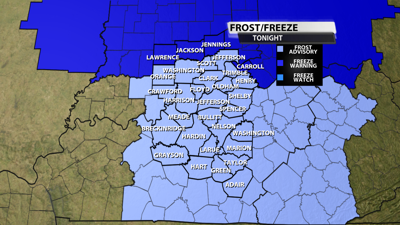
FREEZE WARNING
Carroll-Warren-Tippecanoe-Clinton-Howard-Fountain-Montgomery-
Boone-Tipton-Hamilton-Madison-Delaware-Randolph-Vermillion-Parke-
Putnam-Hendricks-Marion-Hancock-Henry-Vigo-Clay-Owen-Morgan-
Johnson-Shelby-Rush-Sullivan-Greene-Monroe-Brown-Bartholomew-
Decatur-Knox-Daviess-Martin-Lawrence-Jackson-Jennings-
Including the cities of North Vernon, Plainfield, Franklin,
Brazil, Flora, Delphi, Noblesville, West Lebanon, Danville,
Shelburn, Greensburg, Greenwood, Rushville, Mitchell, Vincennes,
Nashville, Seymour, Winchester, Tipton, Farmland, Shelbyville,
Greencastle, Greenfield, Linton, Covington, Carlisle, Lebanon,
Zionsville, Jasonville, Veedersburg, Farmersburg, Worthington,
Muncie, Bloomington, Brownsburg, Terre Haute, Bloomfield,
Indianapolis, Union City, Loogootee, Kokomo, Carmel, Rockville,
Attica, Gosport, Montezuma, Anderson, Columbus, Fairview Park,
Williamsport, Clinton, Rosedale, Shoals, New Castle, Bedford,
West Lafayette, Fishers, Lafayette, Spencer, Martinsville,
Mooresville, Frankfort, Parker City, Sullivan, Washington, and
Crawfordsville
242 AM EDT Fri Apr 11 2025

...FREEZE WARNING IN EFFECT FROM MIDNIGHT TONIGHT TO 9 AM EDT
SATURDAY...

* WHAT...Sub-freezing temperatures as low as 27 expected.

* WHERE...Portions of central, east central, north central, south
  central, southeast, southwest, and west central Indiana.

* WHEN...From midnight tonight to 9 AM EDT Saturday.

* IMPACTS...Frost and freeze conditions could kill crops, other
  sensitive vegetation and possibly damage unprotected outdoor
  plumbing.

PRECAUTIONARY/PREPAREDNESS ACTIONS...

Take steps now to protect tender plants from the cold.
FROST ADVISORY
Orange-Washington IN-Scott IN-Jefferson IN-Dubois-Crawford-Perry-
Harrison IN-Floyd-Clark IN-Hancock-Breckinridge-Meade-Ohio-
Grayson-Hardin-Bullitt-Jefferson-Oldham-Trimble-Henry-Shelby-
Franklin-Scott KY-Harrison KY-Spencer-Anderson-Woodford-Fayette-
Bourbon-Nicholas-Nelson-Washington KY-Mercer-Jessamine-Clark KY-
Larue-Marion-Boyle-Garrard-Madison-Butler-Edmonson-Hart-Green-
Taylor-Casey-Lincoln-Logan-Warren-Simpson-Allen-Barren-Monroe-
Metcalfe-Adair-Russell-Cumberland-Clinton-
Including the cities of Lancaster, New Castle, Paris,
Brownsville, Albany, Elizabethtown, Stanford, Russellville,
Hawesville, Greensburg, Springfield, Georgetown, Hartford,
Hardinsburg, Hodgenville, Danville, Shelbyville, Nicholasville,
Bardstown, Providence, Lexington, Milton, Horse Cave,
Lawrenceburg, Cynthiana, Tompkinsville, Brandenburg, Franklin,
New Albany, Carlisle, Richmond, Frankfort, La Grange, Morgantown,
Madison, Salem, Scottsburg, Corydon, Harrodsburg, Bedford, Paoli,
Winchester, Scottsville, Campbellsville, Liberty, Jeffersonville,
English, Glasgow, Louisville, Jamestown, Lebanon, Bowling Green,
Shepherdsville, Versailles, Lewisport, Jasper, Taylorsville,
Edmonton, Burkesville, Leitchfield, Columbia, and Tell City
332 AM EDT Fri Apr 11 2025 /232 AM CDT Fri Apr 11 2025/

...FROST ADVISORY IN EFFECT FROM 2 AM EDT /1 AM CDT/ TO 9 AM EDT /8
AM CDT/ SATURDAY...

* WHAT...Temperatures as low as 32 will result in frost formation.

* WHERE...Portions of south central Indiana and central Kentucky.

* WHEN...From 2 AM EDT /1 AM CDT/ to 9 AM EDT /8 AM CDT/ Saturday.

* IMPACTS...Frost could harm sensitive outdoor vegetation. Sensitive
  outdoor plants may be killed if left uncovered.

PRECAUTIONARY/PREPAREDNESS ACTIONS...

Take steps now to protect tender plants from the cold.


