

As of Tuesday morning, Laura is now a hurricane moving into the southern Gulf of Mexico. In the next 24-36 hours it will strengthen rapidly before making landfall, potentially as a category 3 hurricane. Here we discuss why and what impacts it will bring:

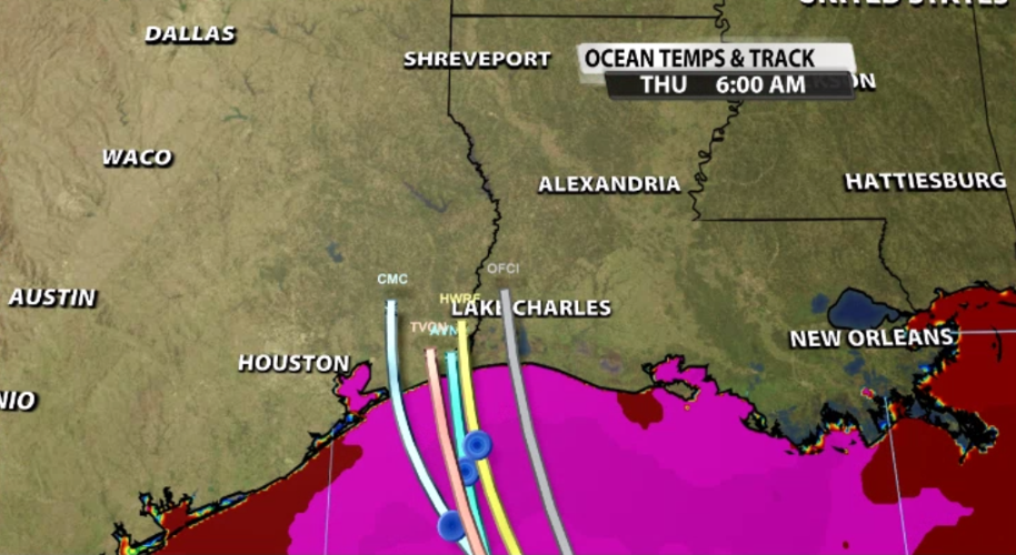
For the past two days, Laura has been crossing Caribbean islands. The land and mountains create friction and interrupt the supply of warm ocean water. Those factors prevented Laura from strengthening much until it got back out into the ocean. Now we are watching that happen. As Laura moves into the southern Gulf of Mexico it has complete access to warm ocean water, which is the fuel hurricanes need to strengthen. In the image below, the pink color represents ocean temperatures in the upper 80 degree to low 90 degree range. The "spaghetti plots" show every model forecasting Laura to move right through that warmest ocean water before making landfall on the mainland.

A hurricane also needs a fairly consistent or calm wind profile. Wind shear happens when wind moves in different directions or at different speeds the higher up you go in the atmosphere. Wind shear can tear a weak tropical system apart and can weaken even a strong hurricane. Land heats and cools faster than water, so at the spot where land and water meet, there is more wind shear. The wind is just trying to carry air to different spots so it will all be the same temperature; doing that at the point where land and water meet can be a challenge. That's why there's an increase in wind shear the closer Laura gets to the coast. The land itself also creates friction which can add to the wind shear.
As it gets closer to landfall, likely within about 10-12 hours of landfall, Laura will start to encounter more of that shear. This is one of the most uncertain parts of this forecast - how much impact will that wind shear have on Laura before landfall?

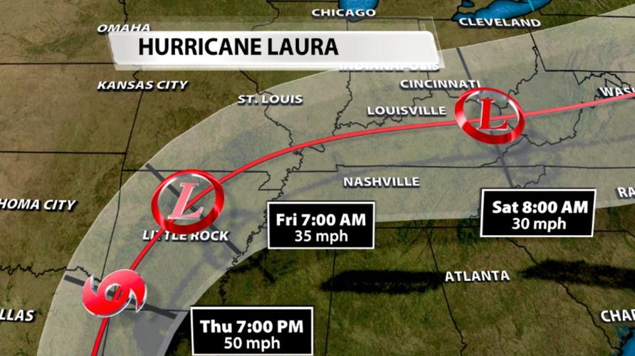
The reason Laura will make such a strange curve this weekend is fascinating. There is a high pressure center in the Atlantic, also called a ridge of high pressure. The wind flow around this ridge is clockwise so the wind pattern is sort of pulling on the remnants of Laura to move farther east. There will also be a cold front approaching from the west. Think about this cold front like a wall; it will not allow the remnants of Laura to go any farther west. With the cold front preventing any westward movement and the ridge pulling the system toward the east, it really doesn't have any other place to go except to take such a sharp easterly curve. That curve will bring the remnants of Laura right through our region. At this point we expect some heavy rain and scattered storms late Friday and Saturday in Kentuckiana, but that forecast will change in the next few days as we see Laura strengthen and make landfall.

If the low pressure center survives that much of a trek across the continent and makes it back out into the Atlantic ocean, it could potentially strengthen again to a tropical storm. That is included in the official forecast track right now and an interesting discussion point, but way too early to be specific about any of that.


