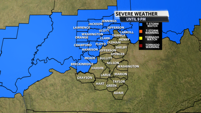

We saw the severe thunderstorm watch earlier only include Carroll county, but as discussed we would likely see another to include much more of our area and here we are. This one does include parts of Metro Louisville and is in place until 9 PM.
This watch is for that second batch of strong to severe showers and storms heading our way through peak heating of the day.

The NWS Storm Prediction Center has issued a
* Severe Thunderstorm Watch for portions of
Southeast Illinois
Southern Indiana
Northwest Kentucky
* Effective this Tuesday afternoon and evening from 130 PM until
800 PM CDT.
* Primary threats include...
Scattered damaging winds likely with isolated significant gusts
to 75 mph possible
Scattered large hail events to 1.5 inches in diameter possible
A tornado or two possible
SUMMARY...A cluster of thunderstorms over southeast Missouri will
track eastward through the afternoon, posing a risk of damaging wind
gusts and some hail.
The severe thunderstorm watch area is approximately along and 55
statute miles north and south of a line from 5 miles north of
Carbondale IL to 35 miles north northeast of Louisville KY. For a
complete depiction of the watch see the associated watch outline
update (WOUS64 KWNS WOU9).
PRECAUTIONARY/PREPAREDNESS ACTIONS...
REMEMBER...A Severe Thunderstorm Watch means conditions are
favorable for severe thunderstorms in and close to the watch area.
Persons in these areas should be on the lookout for threatening
weather conditions and listen for later statements and possible
warnings. Severe thunderstorms can and occasionally do produce
tornadoes.