

The National Oceanic and Atmospheric Administration released it's official outlook for the 2021 hurricane season today. They are expecting 13-20 named storms. Keep in mind a tropical cyclone gets a name when it has wind speeds 39 mph or stronger (that's also when it becomes a Tropical Storm). NOAA is forecasting 6-10 hurricanes will form in the Atlantic this season and 3-5 of those will strengthen to major hurricanes (category 3, 4, or 5). Those are not necessarily landfalling hurricanes in the U.S., so keep that in mind. There's a 70% likelihood of that forecast playing out, which is fairly high confidence. The image below from NOAA shows their forecast.
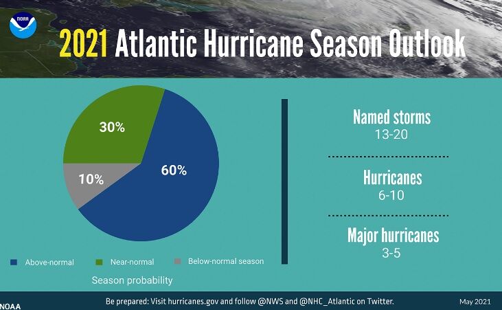
NOAA gives a 60% probability that this will generally be an above average hurricane season. There is a 90% probability this will be an above-average or near-average season. We also learned in the briefing today that what is considered "average" is changing. After 2020 we had a new decade of weather information, and NOAA used that to update the climatological normals. As the climate changes, we have to update what "normal" weather looks like and that process happens every 10 years when we get a new decade of weather information. With the new climate normals that were implemented this month, hurricane averages have also been updated.
| Old Normals: | New Normals: |
| 12 Named Storms | 14 Named Storms |
| 6 Hurricanes | 7 Hurricanes |
| 3 Major Hurricanes | 3 Major Hurricanes |
The bottom line from NOAA is that the 2021 season will see more activity than normal, but less activity than the record 2020 hurricane season. You can click the story below to see which pre-determined names will be used this year. At the end of last season, we ran out of names and started using the Greek alphabet. That will not be done this year if we run out of names on this list.

Since 1953, Atlantic tropical storms had been named from lists originated by the National Hu…
What factors contributed to this forecast
First, it's important to note, we are in a "high activity era" and have been since the late 1990s. It's important to keep that perspective when talking about any forecast. Something significant would need to change to bring us out of that era.
Second, one of the big factors forecasters were looking at this year is our ENSO phase. ENSO stands for El Niño Southern Oscillation, but you're probably more familiar with the terms "El Niño and La Niña" Last year we were in a La Niña. Because of the way La Niña changes wind and ocean patterns, a La Niña usually means increased tropical activity in the Atlantic and El Niño normally suppresses tropical activity in the Atlantic. The last time a below average season was predicted was during the strong El Niño in 2015. This year we are in an ENSO neutral phase as we transition from La Niña to El Niño. That means we don't have a strong signal one way or the other. That one factor by itself would suggest a season near normal, but that's not the only factor to consider.
Sea surface temperatures are also expected to be warm this season, about .38ºC above average. Warm ocean water is like gasoline to a tropical cyclone. The trade winds in the tropical Atlantic are weaker and we have weaker vertical wind shear. Vertical wind shear destroys tropical cyclones, so weaker shear means a more favorable environment for tropical cyclones. Another large-scale pattern that played heavily with the forecasters was the enhanced West African Monsoons we are seeing now. All of these elements help support the forecast of an above average hurricane season, even with the updated seasonal average being higher than last year.
Other Notes from this Call
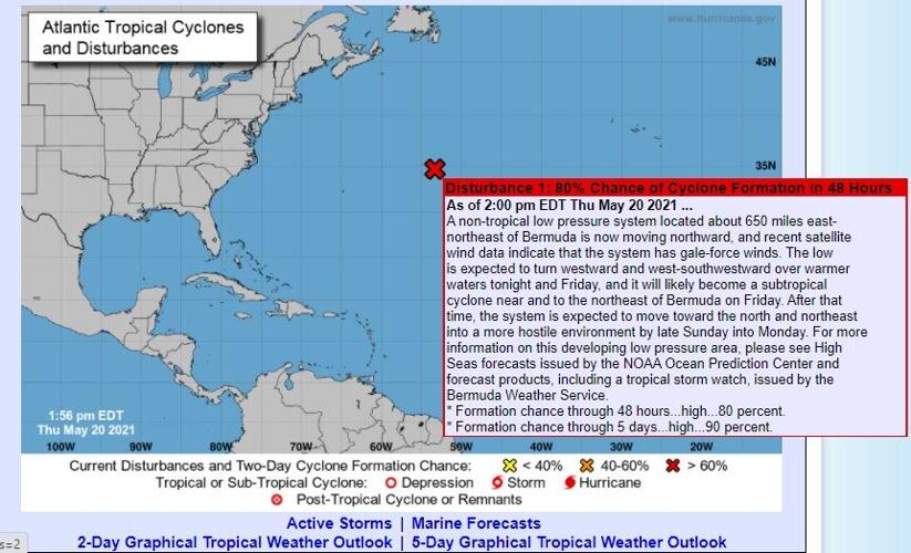
Right now hurricane season is June 1 - November 30. Matthew Rosencrans, Hurricane Season Outlook Lead for NOAA’s Climate Prediction Center, said in the last 10-15 years, about half of those years have seen activity start before June 1. For the 2021 season, the National Hurricane Center started issuing outlooks two weeks earlier (on May 15) than the official season start date. Discussions are happening about moving that hurricane season start date to be earlier (some time in May). That won't happen this year, but watch for updates before 2022 hurricane season. The image below is the National Hurricane Center's first outlook of the season issued on May 15 (see the date in the bottom left corner).

Rosencrans also pointed out when asked several questions about the impacts of climate change on the tropics that climate changed has not been linked to the frequency or overall amount of named storms. Climate change is not one of the factors they considered when making the forecast for expected number of storms this season. However, according to Rosencrans climate change has been linked to heavier precipitation in tropical cyclones (an increase of 3%) and to the intensity of storms and how quickly they intensify. In speaking about impacts of climate change, he added that documented sea level rise makes coastal areas more at risk for storm surge from tropical cyclones.

Another interesting note as we talk about the forecast for hurricane season - we will likely see our first storm of this season form before the end of the weekend. It's not headed toward the U.S., but that would mean yet another season starting before the arbitrary June 1 start date. You can click here to learn more about hurricane hazards and preparedness measures to take.


