
As we talked about yesterday, a quick hitting system is rolling through our area in a few hours. As we also talked about yesterday, it doesn't look like a "high-impact" event at all for most of our area.
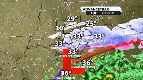
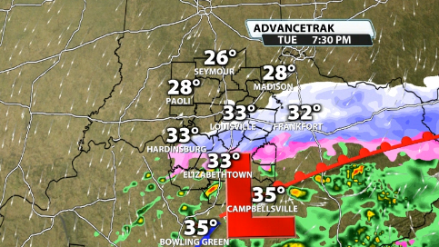
Rain has continued to increase in KY over the last few hours and will continue to move north into the late afternoon. To the north, Indiana has seen snow for much of the afternoon. Indiana has also seen the "deformation zone" form there, which is common on the northern side of the low. That can put down a couple of inches of snow pretty quick. Where that happens will be where the "higher" snow totals end up.
Rain should start to transition to some wet, fat snowflakes after around 4pm-6pm around the Ohio River. There will still be some areas of sleet trying to mix in as well. It likely won't snow for very long, just a few hours likely. The further south you go into Kentucky, the more likely you'll be stuck in a mostly cold rain scenario.
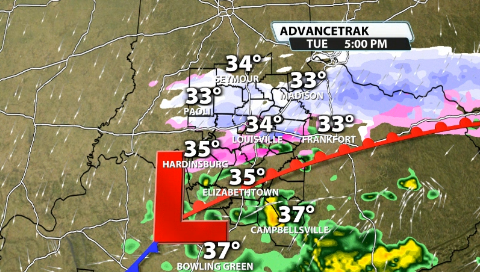
You can see that there is a sharp cut off with this system between cold rain and snow as well. Some freezing drizzle and sleet could infiltrate at times right in between where the cold rain and snow are transitioning, but nothing notably widespread in that regard is expected. Still, if any freezing drizzle occurs, especially overnight tonight, a quick glaze of ice on some elevated surfaces is possible.
The snow and rain start to phase and quickly move to the east and it's out of our hair about as quickly as it came. We should be done with the snow chances by around 10PM in Louisville.
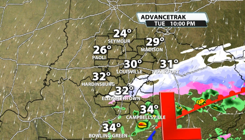
Despite the Winter Weather Advisory, and as we mentioned yesterday, many won't see a ton, but with roads around and below freezing across most of our area still, it doesn't take much to create some slick conditions. Where the snow becomes heavier, it can still quickly cover some roads if there is some intensity with it.
Here's the latest snow total expectations as of 3pm this afternoon. Again, not a high-impact system, but can still cause some issues on the roads where snow ends up.
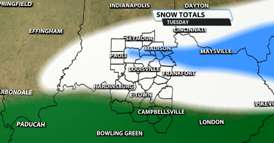
Notice the blue shading...that is for the deformation zone that forms on the northern side of lows during the winter. While a small band, it can put down 1-3" of snow for areas in that shading. That includes areas like French Lick, Madison, Salem, Scottsburg, and Bedford, KY.
Notice the white shading...this is for "up to 1". That means 0 to 1. While a couple local spots could conceivably reach a tad above, most locations will not. We could lose some QPF due to mixing with sleet that could knock that down. This includes areas like Louisville, E-Town, Shepherdsville, Bardstown, Hardinsburg, and Shelbyville.
Notice the green shading...this is for a mostly rain scenario. While some snow could mix in, accumulations are not likely here and it will likely be mostly a cold rain.
Again it's not a lot of snow, but can still cause some issues. Be sure to watch for slick travel Wednesday morning, especially if freezing drizzle occurs overnight tonight. Drizzle can be impactful because it is so light, that all of it can accrete.


