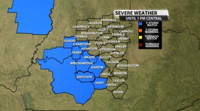
The Storm Prediction Center has issued a Severe Thunderstorm Watch for part of our area until 1 PM Central as severe storms are expected to move through our area.

Below is the text issued with the Watch:
The NWS Storm Prediction Center has issued a

   * Severe Thunderstorm Watch for portions of
     Extreme southern Indiana
     Western and central Kentucky

   * Effective this Thursday morning and afternoon from 750 AM until
     100 PM CDT.

   * Primary threats include...
     Scattered large hail and isolated very large hail events to 2
       inches in diameter possible
     Scattered damaging wind gusts to 70 mph possible

   SUMMARY...A supercell cluster may persist for a few more hours will
   moving south-southeastward from Indiana into Kentucky, with the
   attendant threats of large hail to 2 inches in diameter and damaging
   gusts to 70 mph.


