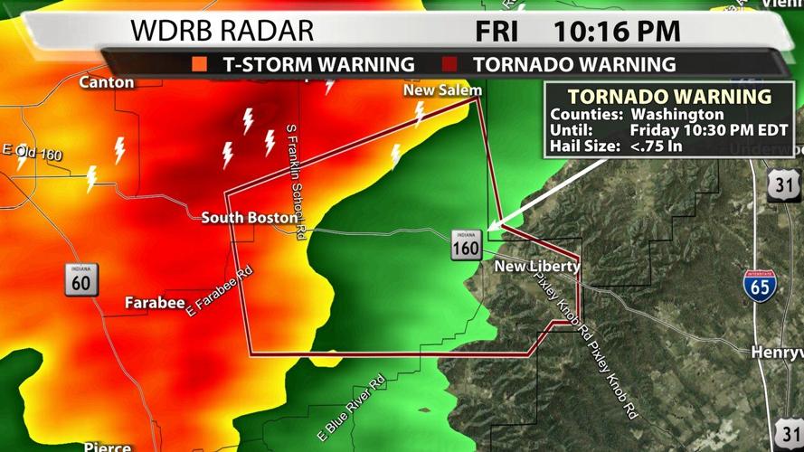

Friday night a tornado warning was issued for part of Washington County, Indiana. Marc and Rick cut into programming to alert you to the potentially dangerous situation.

While on TV they noticed a potential "debris signature" show up on radar. In the picture below you're looking at a radar product called Correlation Coefficient. The spot toward the middle of the screen with different colors is a "hole," something that is different than what is happening around it.
Damage report in Washington County, IN with correlation coefficient. Notice the hole. This is very likely tornado damage. pic.twitter.com/kWTW2og80n
— Marc Weinberg (@MarcWeinbergWX) October 16, 2021
Correlation coefficient is a newer radar product that came with the addition of Dual Polarization. Old radars could only send and receive horizontal pulses of energy, but dual pol radars can send and received in both the horizontal and vertical. There's an animation in this link to help you visualize the difference. This allows us to see the size and shape of objects inside a storm - that's what this CC product is doing. When you see a "hole" like this one in the overall pink shading, that's the radar saying "there's something here that is not the same size/shape as the other stuff around it (rain)." When tracking a tornado or potential tornado, this can be used to signal that debris is being lofted into the air.

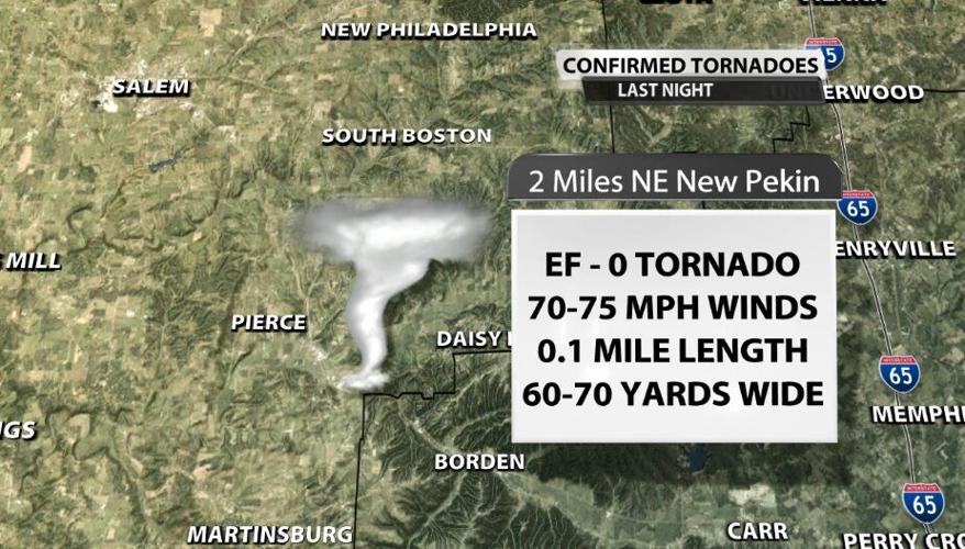
Saturday the National Weather Service damage survey team went out to that same area and found that a tornado did indeed touch down. It was an EF-0 with 70-75 mph winds at the strongest. It looks like it was only on the ground for about a tenth of a mile based on the ground observations and what the NWS employees saw from above using a drone. The tornado was only about 60-70 yards wide at the widest. Here is the summary NWS Louisville released with their findings:
THE NATIONAL WEATHER SERVICE CONDUCTED A STORM DAMAGE SURVEY ACROSS
EASTERN WASHINGTON COUNTY FOR STORMS THAT WENT THROUGH AROUND 1015
PM FRIDAY EVENING. THE SURVEY TEAM FOUND WINDS OF 70 TO 75 MPH IN A
CYCLONIC MANNER ACROSS A VERY SMALL PORTION OF EASTERN WASHINGTON
COUNTY NEAR PINE HILL HILL LAKE. A VERY NARROW AREA OF TREE AND ROOF
DAMAGE OCCURRED JUST SOUTHWEST OF THE LAKE.

TREES WERE FACING TO THE NORTH, NORTHEAST, AND EASTERLY DIRECTION.
ONE CAR PORT, HAD SIGNIFICANT DAMAGE FROM LARGE OAK LIMBS FALLING IN
IT MINOR ROOF DAMAGE OCCURRED, INCLUDING SHINGLES AND LARGE LIMBS
FALLING ON A FEW HOMES. ONE TREE FELL ON A A HOMEOWNERS PICK UP
TRUCK, RESULTING IN SIGNIFICANT DAMAGE.

THE SURVEY TEAM FLEW A DRONE WHICH CONFIRMED TREES FACING IN
MULTIPLE DIRECTIONS ALONG WITH TWISTING AND SNAPPING OF SOFTWOOD AND
HARDWOOD TREES.
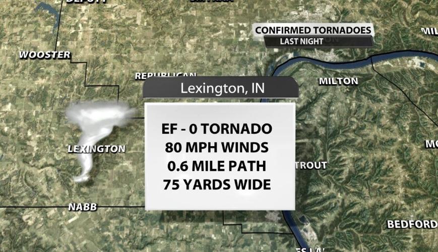
The survey team also went to Lexington, Indiana, on Saturday. After the storms passed through Friday night, reports came in of many trees down in the area, so they went out to investigate whether or not that was caused by a tornado. They also found damage here from an EF-0 tornado with maximum winds of 80 mph. This path was more than half a mile long, and the tornado was 75 yards wide. Here is the summary from this tornado:
THE NATIONAL WEATHER SERVICE IN LOUISVILLE CONDUCTED A STORM DAMAGE
ASSESSMENT SURVEY ACROSS SCOTT COUNTY, INDIANA. THE SURVEY TEAM
FOUND DAMAGE CONSISTENT WITH 80 MPH WINDS IN LEXINGTON, INDIANA. THE
TORNADO BEGAN AT THE LEXINGTON CEMETERY AND CONTINUED ALL THE WAY TO
THE LEXINGTON FIRE AND RESCUE. THE TORNADO UPROOTED, TWISTED, AND
SNAPPED NUMEROUS TREES AT THE CEMETERY WITH THE TREES FALLING IN A
NORTHERLY, NORTHEASTERLY, SOUTHEASTERLY AND EVEN A FEW THAT POINTED
TO THE SOUTHWEST. THIS IS WHERE THE WIDEST PART OF THE TORNADO WAS
OBSERVED WITH APPROXIMATELY A 75 YARD WIDTH.

SEVERAL TREES WERE SNAPPED ALONG CHARLESTOWN ROAD WITH MORE
SIGNIFICANT DAMAGE ALONG S STUARD ST. A COUPLE OF HOMES HAD SHINGLE
DAMAGE AND LOOSE ITEMS SUCH AS GAS CANS AND GARDEN DECORATIONS THAT
WERE THROWN 50 YARDS.

POWER CREWS WERE WORKING FEVERISHLY TO RESTORE POWER ALL ALONG SOUTH
MULBERRY STREET, WHERE TREES WERE THROWN IN MULTIPLE DIRECTIONS AND
ACROSS POWER LINES. POWER COMPANY WORKERS TOLD US THAT SEVERAL OF
THE POWER POLES WERE SNAPPED OR CRACKED.

THE TORNADO CONTINUED ALONG S. CHERRY ST. WITH A VERY NARROW PATH OF
ONLY 40 TO 50 YARDS, AND LIFTED AROUND THE LEXINGTON FIRE AND
RESCUE. SEVERAL WITNESSES TOLD US THAT THEY HEARD WINDOWS BEING
OPENED UP AND A DISTINCT ROAR IN THE AIR.
Here's video from the NWS Louisville drone of the damage they found around Lexington, Indiana.
Aerial views of tornado damage near Lexington, IN from an EF-0 tornado that struck the night of October 15, 2021.
---------------------------------
National Weather Service
Weather Forecast Office
Louisville, KY
WDRB reporter Breon Martin went out to see the damage and met up with the National Weather Service while they were conducting their official storm survey. Click this tweet below to see his thread with other images and an interview with John Gordon from the Louisville National Weather Service office.
Following severe weather and tornado warnings last night — large trees were snapped in half and storm damage can be seen all throughout Lexington, IN today. A resident I spoke with says “It got ugly in seconds.” She also says her family is lucky to be alive. @WDRBNews pic.twitter.com/eAzmakJAxW
— Breon Martin (@BreonMartin) October 16, 2021
Tune into WDRB News tonight at 10 to see more video from these areas and interviews from people nearby.


