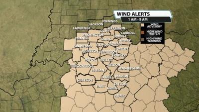


A wind advisory has been issued for our area ahead of the front that will bring us showers and storms tonight and on Sunday. Winds will be whipping around our area regardless of the storms. Almost everyone in our viewing area is included. This is in effect from 1AM tonight through 9 AM Sunday morning.

This is for isolated wind gusts climbing to 45-50mph at times. Here's more on the advisory from the NWS-Louisville.
...WIND ADVISORY IN EFFECT FROM 1 AM EDT /MIDNIGHT CDT/ TO 9 AM EDT
/8 AM CDT/ SUNDAY...
* WHAT...South winds 10 to 20 mph with gusts up to 40 mph expected.
Isolated gusts of 45 to 50 mph are possible.
* WHERE...All of southern Indiana and central Kentucky.
* WHEN...From 1 AM EDT /midnight CDT/ to 9 AM EDT /8 AM CDT/ Sunday.
* IMPACTS...Gusty winds will blow around unsecured objects. Tree
limbs could be blown down and a few power outages may result.
* ADDITIONAL DETAILS...The strongest winds will likely occur just
ahead of a cold front that will pass through the region early
Sunday morning. Behind the front on Sunday morning, there will be
a period of lighter winds. However, westerly winds will increase
by late Sunday morning and into Sunday afternoon with gusts of 25
to 35 mph.


