This post has been updated. The Warning information is at the bottom with more current forecast information at the top.
Now that the snow has started to fall in our area, let's discuss what to expect through the night and Friday morning.
If you haven't seen it yet, you will see a transition from rain to sleet briefly then to snow. Temperatures will drop quickly through that time period. Once you reach the mid-20s, your area will "flash freeze." That's not hype - it just means temps going from above freezing to the middle or lower 20s within just a few hours (for some of you it will only be a few minutes) causing water to freeze instantly without a chance to treat or remove it.
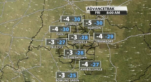
That cold *is* the story. The cold will freeze liquid water, but it will also make it dangerous for you to be outside Friday with uncovered skin. Frostbite can set in in as little as 15-20 minutes with this level of cold.
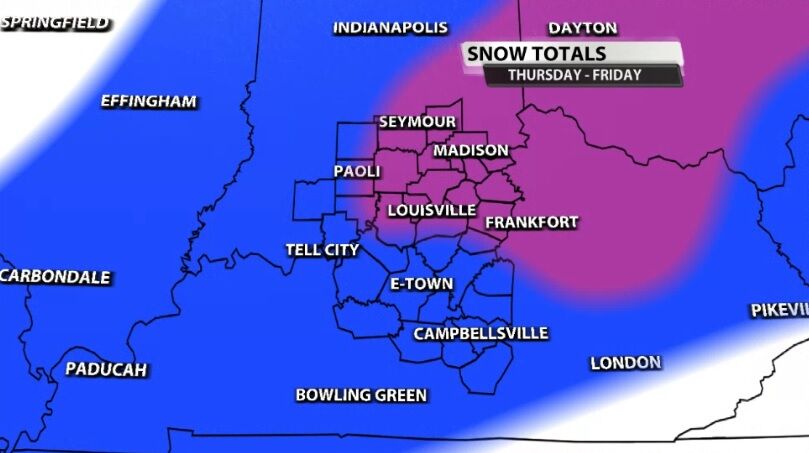
Snow is falling now and will start to wrap up shortly after midnight. Our snow totals map is below. The white shading are the lightest totals - generally 1"-2" including what has already started to fall. The blue shading is more widespread where we expect 2"-4" of snow, and the purple represents where the highest totals are likely. That's where we are expecting 3"-6" of snow.
The National Weather Service office in Louisville has issued a Winter Storm Warning for all of our area until Friday afternoon. Everyone shaded in dark blue is covered by this new Warning. Remember to treat any weather Warning just as seriously as you would a Tornado Warning or Thunderstorm Warning.
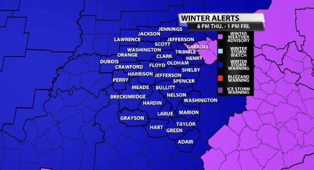
Below is the text issued with this new warning:
..WINTER STORM WARNING IN EFFECT FROM 6 PM EST /5 PM CST/ THIS
EVENING TO 1 PM EST /NOON CST/ FRIDAY...
...WIND CHILL WARNING REMAINS IN EFFECT FROM 10 PM EST /9 PM CST/
THIS EVENING TO 1 PM EST /NOON CST/ FRIDAY...
* WHAT...Total snow accumulation 2 to 3 inches, locally up to 4
inches. Winds gusting as high as 45 mph, resulting in near
blizzard conditions at times, and dangerously cold wind chills
as low as 30 below zero.
* WHERE...Southern Indiana and central Kentucky.
* WHEN...This evening through Friday afternoon.
* IMPACTS...Hazardous travel conditions could impact the Friday
morning The cold wind chills could cause frostbite on exposed
skin in less than 30 minutes.
PRECAUTIONARY/PREPAREDNESS ACTIONS...
If you must travel, keep an extra flashlight, food, and water in
your vehicle in case of an emergency.
Avoid outside activities if possible. When outside, make sure you
wear appropriate clothing, a hat, and gloves.
In Indiana, for Indiana Road Conditions please visit
http://pws.trafficwise.org In Kentucky, for Kentucky Road
Conditions please visit http://goky.ky.gov


