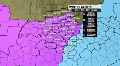
The National Weather Service office in Louisville issued a Winter Weather Advisory for most of our communities and a Winter Storm Watch for a few spots. Both the Advisory and Watch are in place from Friday night through Saturday morning when snow will be falling in our area.

The light blue shading is the Winter Storm Watch which will either become an Advisory or a Warning before the snow starts. The pink shading is a Winter Weather Advisory for most of our area. The Watch was issued to highlight an area that will see more snow accumulate. Below is the text issued by the National Weather Service office with the Advisory. We have a conference call with the NWS this afternoon to discuss the snow and this forecast, so more information will be posted on the WDRB Weather blog in a few hours.
...WINTER WEATHER ADVISORY IN EFFECT FROM 7 PM EST /6 PM CST/
FRIDAY TO 10 AM EST /9 AM CST/ SATURDAY...

* WHAT...SNOW EXPECTED. TOTAL SNOW ACCUMULATIONS OF 1 TO 3
  INCHES.

* WHERE...SOUTHERN INDIANA AND PORTIONS OF WEST-CENTRAL AND
  WESTERN KENTUCKY.

* WHEN...FROM 7 PM EST /6 PM CST/ FRIDAY TO 10 AM EST /9 AM CST/
  SATURDAY.

* IMPACTS...PLAN ON SLIPPERY ROAD CONDITIONS FRIDAY EVENING AND
  SATURDAY MORNING.

* ADDITIONAL DETAILS...BITTER COLD WIND CHILLS IN THE TEENS
  EXPECTED BY SATURDAY MORNING.

PRECAUTIONARY/PREPAREDNESS ACTIONS...

SLOW DOWN AND USE CAUTION WHILE TRAVELING.

IN INDIANA, FOR INDIANA ROAD CONDITIONS PLEASE VISIT
HTTP://PWS.TRAFFICWISE.ORG.

IN KENTUCKY, FOR KENTUCKY ROAD CONDITIONS PLEASE VISIT
HTTP://GOKY.KY.GOV


