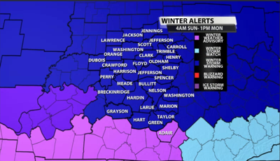


To no surprise, our winter storm watch has been upgraded to a winter storm warning for our entire area except for Adair county, who is included in a winter weather advisory. The winter storm warning is in effect from 4AM Sunday through 1PM Monday.

Ice storm warnings remain to our west and do not include our area for now, due to the range of precipitation types in our area through the entire event Sunday morning through Monday afternoon. Here's more on the warning from the NWS...
* WHAT...A wintry mix of snow, sleet, and freezing rain is expected
  from early Sunday morning through Monday afternoon. Southern
  Indiana is expected to receive snow/sleet amounts of 6-10 inches,
  with ice accumulations of 0.2 to 0.5 inches. North central
  Kentucky is expected to receive snow/sleet amounts of 2 to 6
  inches and ice accumulations of 0.2 to 0.6 inches.

* WHERE...Southern Indiana and much of central Kentucky.

* WHEN...From 4 AM EST /3 AM CST/ Sunday to 1 PM EST /noon CST/
  Monday.

* IMPACTS...Power outages and tree damage are likely due to the ice.
  Travel could be nearly impossible. The hazardous conditions could
  impact the Monday morning commute.
PRECAUTIONARY/PREPAREDNESS ACTIONS...

Persons should consider delaying all travel. If travel is absolutely
necessary, drive with extreme caution. Consider taking a winter
storm kit along with you, including such items as tire chains,
booster cables, flashlight, shovel, blankets, and extra clothing.
Also take water, a first aid kit, and anything else that would help
you survive in case you become stranded.
We will have another blog coming out later on Saturday morning that will dive more into timing and totals. Be on the lookout for that and tune in to all WDRB newscasts as the WDRB Weather Team continues to update impacts for this storm.


