Top Story
Greater snow totals are to the south of Louisville, after a storm moved through late Sunday into Monday morning.
Greater snow totals are to the south of Louisville, after a storm moved through late Sunday into Monday morning.
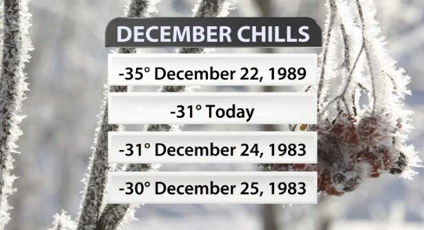
We have now made it through the coldest part of this winter storm! Temperatures (and wind chills) will stay dangerously low, but it does slowly get better from here. We all know this system brought crazy cold air, but you might be surprised at how some of these statistics stack up!
A new Wind Chill Advisory has been issued for our area to cover the rest of the day Friday through mid-afternoon Saturday.
The National Weather Service in Louisville has issued a Wind Chill Watch and Winter Weather Advisory for nearly all of our area.
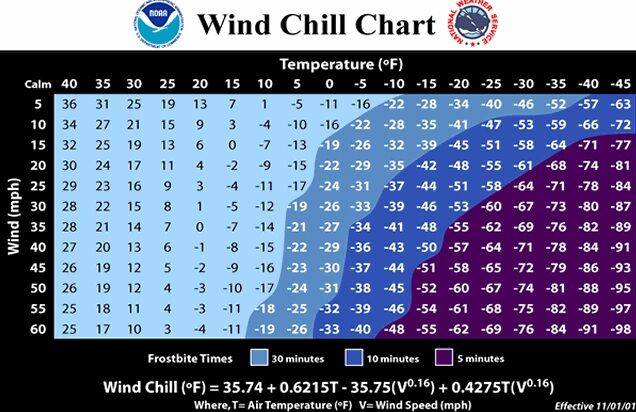
When temperatures really start to tumble in the winter, you will often hear us refer to the wind chill. Many times when we bring up "what the air feels like," we get a lot of questions about what that really means.
During the winter season, we get a lot of weather alerts from the National Weather Service. You have probably heard us talk about Ice Storm Warnings, Winter Weather Advisories, and even Winter Storm Watches. Each of our winter alerts means something slightly different, so let's make sure we are on the same page when it comes to these winter threats.

When temperatures really start to tumble in the winter, you will often hear us refer to the wind chill. Many times when we bring up "what the air feels like," we get a lot of questions about what that really means.
The National Weather Service has issued a Wind Chill Advisory beginning Wednesday morning for dangerous wind chills across the area. The exact start time and expected wind chill varies by location.
Temperatures are about to drop roughly forty degrees in less than 40 hours. Yes, it is January and recently our temperatures have been well above average, but this cold snap will over-correct.