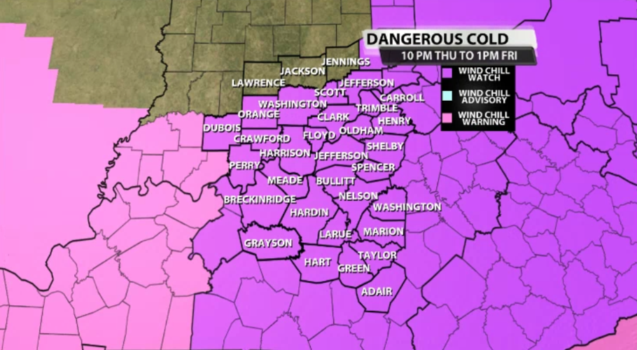
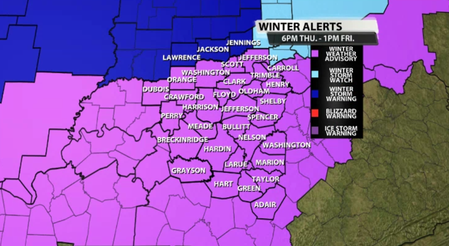
The National Weather Service in Louisville has issued a Wind Chill Watch and Winter Weather Advisory for nearly all of our area. There is still a Winter Storm Warning in effect for Jackson, Jennings, and Lawrence counties. Since your alerts come from the NWS office in Indianapolis, there are slightly different criteria for these alerts. We are expecting more snow in those communities, too. There have been a LOT of "alerts" (watches/warnings/advisories) issued and discussed in the last few days to address what's about to happen, so let's take a moment to walk through what all of this means for you.

Wind Chill Watch: With temperatures dropping into the single digits, and even briefly below zero, the air will feel unusually cold. Add to that the wind blowing consistently over 20 mph with gusts up to 50 mph possible, and the wind chill will quickly become dangerous. This means the wind chill can drop as low as 25 degrees below zero. Wind chills will likely stay below zero through Friday and Saturday.

Winter Weather Advisory: Since the Wind Chill Watch covers the cold factor, this Winter Weather Advisory addresses the snow and potential for blowing snow. We are expecting accumulating snow after the temperatures drop to switch us from light rain to heavier snow. As the wind picks up, that snow will start to blow around, too. That will make driving a little more tricky on Friday.
Below is the text issued by the National Weather Service with the Winter Weather Advisory and the Wind Chill Watch:
...WINTER WEATHER ADVISORY IN EFFECT FROM 6 PM EST /5 PM CST/
THURSDAY TO 1 PM EST /NOON CST/ FRIDAY...
...WIND CHILL WATCH IN EFFECT FROM THURSDAY EVENING THROUGH
FRIDAY AFTERNOON...

* WHAT...TOTAL SNOW ACCUMULATIONS OF 1 TO 3 INCHES. WINDS GUSTING
  AS HIGH AS 45 MPH, RESULTING IN DANGEROUSLY COLD WIND CHILLS AS
  25 BELOW ZERO.

* WHERE...PORTIONS OF AND SOUTH CENTRAL INDIANA AND NORTH
  CENTRAL, NORTHWEST AND SOUTH CENTRAL KENTUCKY.

* WHEN...FOR THE WINTER WEATHER ADVISORY, FROM 6 PM EST /5 PM
  CST/ THURSDAY TO 1 PM EST /NOON CST/ FRIDAY. FOR THE WIND
  CHILL WATCH, FROM THURSDAY EVENING THROUGH FRIDAY AFTERNOON.

* IMPACTS...PLAN ON SLIPPERY ROAD CONDITIONS. THE HAZARDOUS
  CONDITIONS COULD IMPACT THE THURSDAY EVENING AND FRIDAY MORNING
  COMMUTE. THE COLD WIND CHILLS COULD CAUSE FROSTBITE ON EXPOSED
  SKIN IN LESS THAN 30 MINUTES.

PRECAUTIONARY/PREPAREDNESS ACTIONS...

SLOW DOWN AND USE CAUTION WHILE TRAVELING.

MONITOR THE LATEST FORECASTS FOR UPDATES ON THIS SITUATION.

IN INDIANA, FOR INDIANA ROAD CONDITIONS PLEASE VISIT
HTTP://PWS.TRAFFICWISE.ORG IN KENTUCKY, FOR KENTUCKY ROAD
CONDITIONS PLEASE VISIT HTTP://GOKY.KY.GOV


