
We're finally starting to come out on the other end of a very busy and wet weather pattern over the last couple of weeks. While the new drought monitor comes out on Thursday, we already have a good idea on how much rain we've caught up on over the last couple of weeks.
Louisville
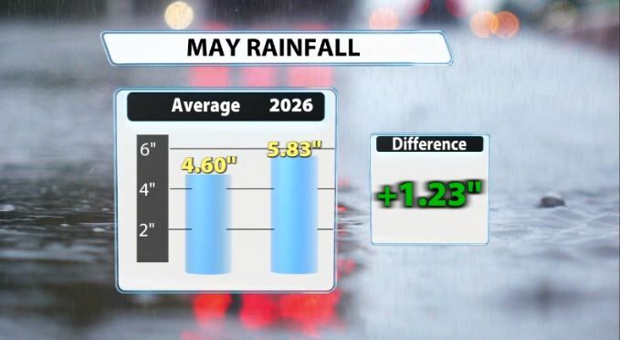
Louisville has seen measurable rainfall the last 9 of 11 days, not including today. That's wild! Now generally, May is the wettest month of the year in Louisville, but we are still riding pretty far above normal for the month. Since May 1st, we've received 5.83" of rain. 4.9" of that 5.83" has fallen since May 16th alone. May 2026 (so far) is the 22nd wettest May on record in Louisville and currently has us 1.23" above normal to date.
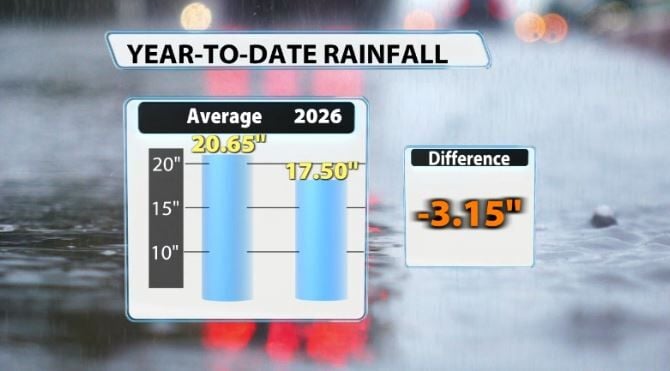
For the year now, Louisville has seen 17.5" of rain. To date, we average around 20.65". That still puts us at a 3.15" deficit on the year. That's a lot better than it was, when we were at one point in late April, we were 6.67" short on the year.
Southern KY
Obviously our southern Kentucky communities have had the worst drought in our entire area. Luckily, they've also received the most amount of rainfall this month. That's a good thing, because extreme drought was continuing to spread to a lot of our Kentucky counties.
For example, LaRue county's mesonet site has received 6.69" of rain since May 19th alone, Grayson County's mesonet site has received 6.39" of rain the last 3 weeks, and Taylor County's mesonet site has received 5.09" of rain the last 3 weeks. This is drought-busting rainfall!
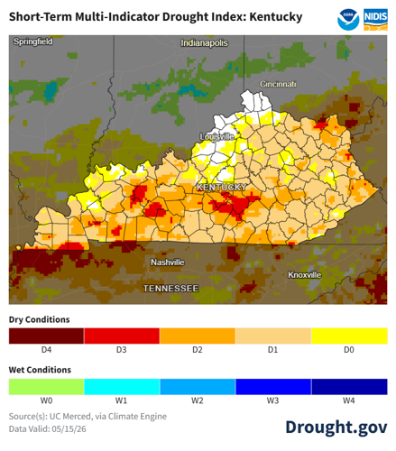
The current Short-Term Multi-Indicator Drought Index from Drought.Gov shows estimates multiple areas in Kentucky will see improvement by the time the next drought monitor comes out. This estimates current drought conditions across the U.S. by integrating several key drought monitoring indices into a single objective, computer-generated map. This experimental drought map is based on the methodology developed at the NOAA National Weather Service's Climate Prediction Center.

Source(s): UC Merced, via Climate Engine, Drought.gov
Now, much of our Kentucky counties were so far behind that it will not completely eliminate drought, but the recent rain should definitely help out.
Rivers & Lakes
Many of our lakes and rivers across the state, particularly in our southern counties, were struggling bad in terms of very low water levels. Since the recent rain, Rough River Lake is up 13.46 feet in the last week alone and Nolin Lake is up 5.11 feet in the last week!


