


When we have severe weather chances in our area, especially in spring, you'll hear us a lot on tv or online mention outlooks that could be "slight", "enhanced", "moderate", or the rare "high" risks that could be outlined for our area. When you see our area highlighted under a certain color with one of those terms, do you know what they mean? If not, here's an explanation/refresher that could be very important during severe weather season!
What is "severe weather"?
The NWS defines a severe thunderstorm as any storm that produces one or more of the following elements:
- A tornado.
- Damaging winds or speeds of 58 mph (50 knots) or greater.
- Hail 1 inch in diameter or larger.
The SPC further defines significant severe thunderstorms as any storm that produce one or more of the following elements:
- A tornado that produces EF2 or greater damage.
- Wind speeds of 75 mph (65 knots) or greater.
- Hail 2 inch in diameter or larger.
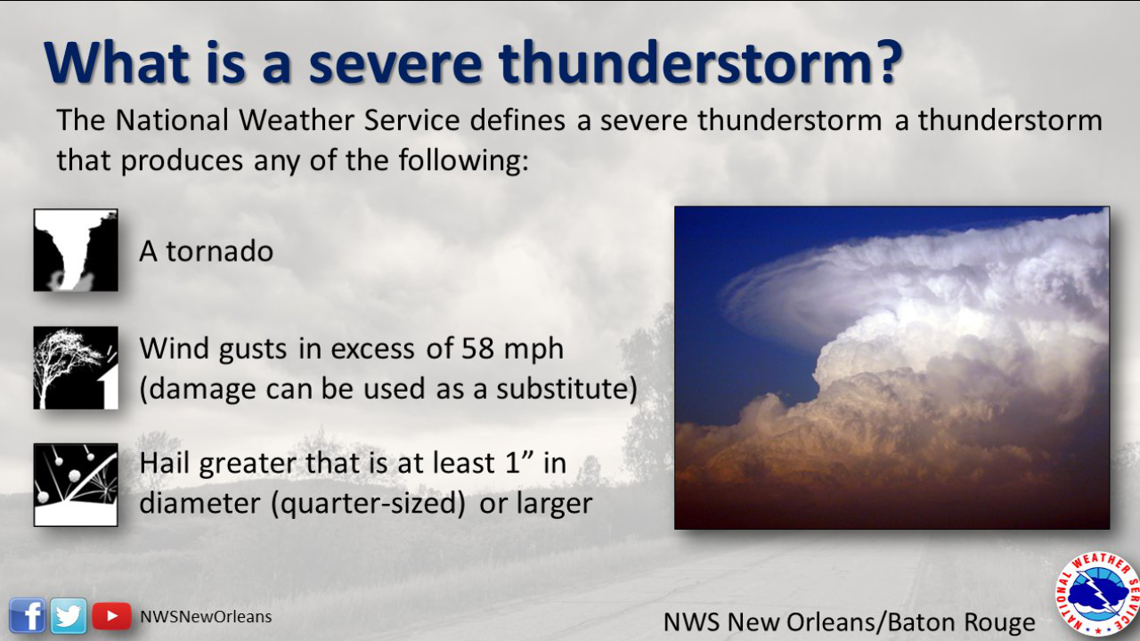
Image: NWS New Orleans
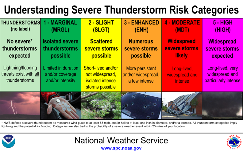
SPC Outlooks
The Storm Prediction Center is in charge of issuing severe risks for the entire country every single day. If severe weather is possible in a location, they will issue a "convective outlook" for that area that could fall under 1 of 5 levels. Those being marginal, slight, enhanced, moderate, and high.
Each level is a step up from the one before it based on a number of different things. That could be confidence in the forecast, a larger threat for a specific impact (ex:hail, tornadoes, wind), or a combination. So, what does each one mean and do you know which term is associated with the most widespread severe weather chances?
Marginal
A marginal risk by the Storm Prediction Center is not one that we at WDRB show on tv because it is not supposed to be put in place to represent an organized widespread severe weather chance. According to the SPC, a marginal risk is defined as "An area of severe storms of either limited organization and longevity, or very low coverage and marginal intensity."
We may have a marginal risk out for our area during a summer day where a couple pop-up storms could have strong winds that could reach severe criteria or a few that could bring in large hail. It is not meant to be used for normal pop-up storms or organized severe weather.
Slight
The next step up from a marginal is a slight risk. You could label this as level 2 out of 5. We see these pretty often for our area, especially this time of year. The SPC describes a slight risk as "An area of organized severe storms, which is not widespread in coverage with varying levels of intensity.". Whenever we are placed under a slight risk, we should experience short lived, but sometimes intense severe storms that are scattered about within that slight risk. The slight risk is labeled with a yellow color that you will often see us showing on TV.
Enhanced
Not to be confused with the wording, an enhanced risk for severe storms is the next step up from a slight risk. This could be labeled as level 3 out of 5. This is where we start talking about the chance for more widespread severe weather, often including an increased likelihood for tornadoes. The SPC defines an enhanced risk as "An area of greater (relative to Slight risk) severe storm coverage with varying levels of intensity." Basically, this is similar to a slight risk but in more widespread fashion and with the possibility for stronger storms. The enhanced risks are labeled as an orange color that you'll see on TV.
Moderate
While the wording can be confusing (trust us, we get it), a moderate risk is where things start to become more dangerous. This is the next step up from an enhanced risk and could be labeled as level 4 out of 5. The SPC defines a moderate risk as "An area where widespread severe weather with several tornadoes and/or numerous severe thunderstorms is likely, some of which should be intense. This risk is usually reserved for days with several supercells producing intense tornadoes and/or very large hail, or an intense squall line with widespread damaging winds." Notice the wording from the SPC becomes more specific on the potential impacts and a little more in depth. We see these issued for days that could see widespread tornado outbreaks that could bring strong, long-lived tornadoes. A moderate risk is labeled with a red color when you see it on TV.
High
Lastly, but most certainly not least, is the rare high risk. This is the highest level of a severe risk that can be issued and could be labeled as a level 5 out of 5. The SPC defines a high risk as "An area where a severe weather outbreak is expected from either numerous intense and long-tracked tornadoes or a long-lived derecho-producing thunderstorm complex that produces hurricane-force wind gusts and widespread damage. This risk is reserved for when high confidence exists in widespread coverage of severe weather with embedded instances of extreme severe (i.e., violent tornadoes or very damaging convective wind events)." Again with this description, you'll notice a much stronger wording and specific impacts mentioned. These risks are not issued very often and are used only for when widespread outbreaks look imminent. In fact, since 2020, there has only been 5 days with a high risk. The last high risk issued for our area was for a few of our Indiana counties on November 17th, 2013 and March 2nd, 2012.
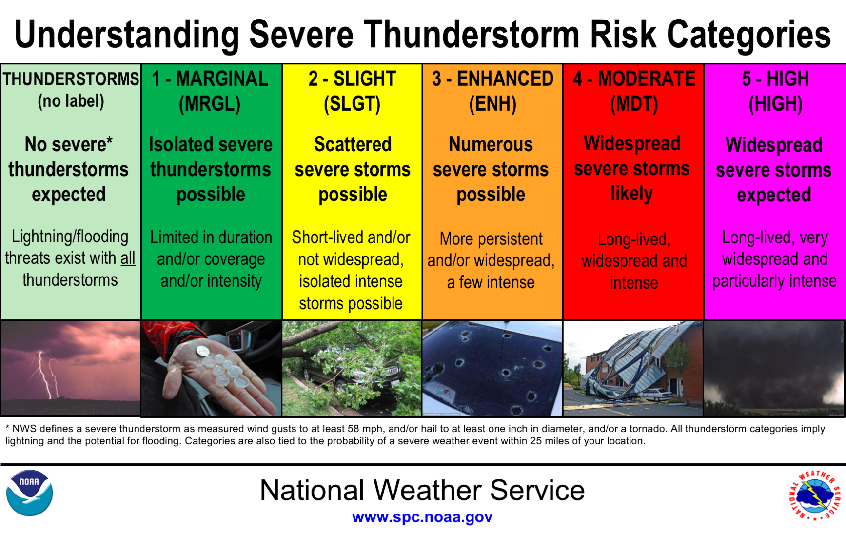
Image: Storm Prediction center
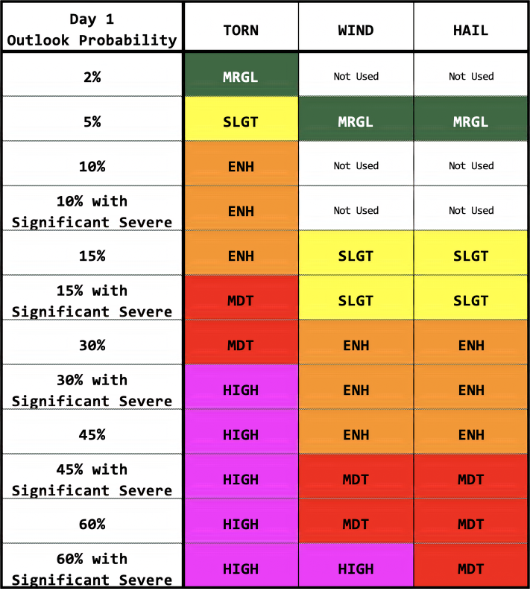
Image: Storm Prediction center


