
Don't panic - we're not predicting a major snow storm here. But as a cold front comes through this week, it's possible a few snowflakes could mix in with the raindrops. With that in mind, I (Hannah) was curious about our latest spring snowfall in Kentuckiana. Good news - the National Weather Service keeps records on that!
The latest ever snowfall in Louisville happened on May 20, 1894. The NWS Louisville office wrote, "Cold Canadian air poured southward between high pressure over the Upper Plains and low pressure moving up the East Coast. The East Coast low threw copious amounts of Atlantic moisture as far west as Kentucky’s Blue Grass." Louisville only received a "trace" of snow which is less than a tenth of an inch but more than zero. However, other Kentucky communities saw much more snow than that! Here are some other snow totals from that day (via NWS Louisville):
- Lexington, Harrodsburg, and Mount Sterling: 6”
- Shelbyville and Richmond: 4”
- Burnside and Eubank: 3”
- Sandy Hook and Shelby City: 2”
- Hendricks: 1”
NWS also recorded a few comments from weather observers around the state which provide a really interesting account of this crazy snow! These are listed based on the location the report came from:
- Greendale (northern Fayette County): “Snow was heavy – flattened all the wheat to the ground, breaking much of it”.
- Harrodsburg: “A remarkable snowstorm. Peach trees as well as many other kinds – vegetables, grains are bent to the ground. Great destruction to fruit and shade trees as well as rye wheat.”
- Richmond: “There was probably more snow fell on the 20th than four inches yet it melted so fast next to the ground.”
May 20th is the latest there has ever been snowfall in Louisville, but the latest *measurable* snowfall (more than just a trace) happened on May 6, 1898. This is also the only measurable snowfall that has ever happened in May in Louisville. NWS wrote, "High pressure over the Great Plains teamed up with low pressure over the southeast United States to provide enough moisture and cold air to spark light snow across portions of Kentucky." This snowfall wasn't quite as heavy across the state, though more snow did fall in Louisville compared to the May 20 event. Here are the totals via NWS:
- Shelbyville: 2”
- Irvington: 1.5”
- Lexington: 1.2”
- Louisville: 1.0”
- Elizabethtown: 0.5”
- Caddo, Greensburg, Leitchfield, Owenton, Loretto, Shelby City, and Scott: Trace
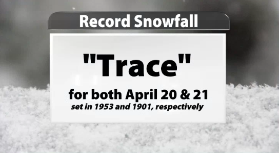
Keep checking our blog and our forecasts on TV in the next day or two to keep updated on the chance to see snowflakes this week. Even if we were to see measurable snow, it still wouldn't be the latest snow we've had in Louisville. However if we do get measurable snow in Louisville either on Tuesday or Wednesday, that will set a record. The current snowfall record for both April 20th and April 21st is just a trace of snow. Those records were set in 1953 and 1901 (also in earlier years), respectively.


