

As of yesterday, we have a new satellite orbiting above Earth as NOAA, NASA, and Elon Musk's SpaceX joined together to make it happen. This will aide in forecasting the weather across the U.S. and the world. NOAA explains the historical significance of this new satellite:

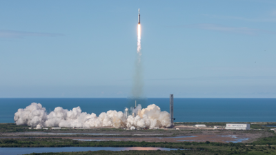
NOAA's GOES-U satellite launches aboard a Space X Falcon Heavy rocket from NASA's Kennedy Space Center Launch Complex 39A (Image credit: Amber Jean Notvest/NASA)
GOES-U, the latest of NOAA’s four advanced geostationary satellites, soared into orbit on a SpaceX Falcon Heavy rocket at 5:26 p.m. EDT (Tuesday) from NASA’s Kennedy Space Center in Florida. The launch team confirmed the satellite’s solar array panels have deployed, and GOES-U is operating under its own power.
After approximately two weeks, GOES-U will reach geostationary orbit at 22,236 miles above Earth and will be renamed GOES-19. Following a thorough checkout and validation of its instruments, the new satellite will shift to the GOES-East position and replace GOES-16 in the mid-2025 time frame.
“GOES-U will combine high definition with advanced speed and precision to the real-time observations it will capture, which will help improve the accuracy and timeliness of our weather forecasts,” said NOAA Administrator Rick Spinrad, Ph.D. “Also, this satellite will ensure these critical data are available to NOAA forecasters into the 2030s.”
GOES-U is making history by carrying the first operational satellite solar coronagraph (CCOR-1). This instrument will work in tandem with the satellite’s other solar and space environment technology to detect hazardous space weather that could disrupt power grids, communications and navigation systems.
"GOES is one of the most valuable tools that our meteorologists and hydrologists have in their observational toolbox,” said NOAA National Weather Service Director Ken Graham. “This satellite will add to the current imaging capabilities for hurricanes, fires, severe storms and other life-saving applications, including the new coronagraph that will expand warning lead times for geomagnetic storms.”
GOES-U is also historic because “it completes the GOES-R series of four satellites that were first conceived more than 20 years ago and is expected to operate into the late 2030s,” said Steve Volz, Ph. D., assistant administrator for NOAA’s Satellite and Information Service.
Like the previous satellites in the GOES-R series, GOES-U will provide fast, accurate data for tracking severe storms, tropical systems, destructive wildfires (and the smoke they emit), floods, lightning, snow storms, dense fog and other hazards that threaten the U.S. GOES-U will work in sync with GOES-18, which is perched in the GOES-West position, to observe more than half the globe — from the west coast of Africa to New Zealand, and from Alaska to Antarctica.


