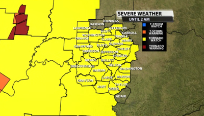


The tornado watch has been expanded to include more of our viewing area which does include Louisville. This watch is in effect until 2 AM.

Here's more from the SPC on the watch:
The NWS Storm Prediction Center has issued a
* Tornado Watch for portions of
Southern Indiana
Central Kentucky
* Effective this Wednesday night and Thursday morning from 720 PM
until 200 AM EDT.
* Primary threats include...
Several tornadoes and a couple intense tornadoes likely
Widespread damaging wind gusts to 70 mph likely
Scattered large hail and isolated very large hail events to 2
inches in diameter likely
SUMMARY...Isolated supercell thunderstorms over middle Tennessee
will track northeastward this evening, posing a risk of large hail
and tornadoes. More widespread thunderstorms by late evening will
affect the region, with concerns for damaging winds and isolated
tornadoes.


