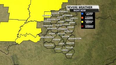

The Storm Prediction Center has issued a tornado watch for the following highlighted county ahead of the severe chance we have later this afternoon and tonight. The watch for Lawrence county is through 8PM EDT. The SPC has only included Lawrence county, Indiana for now, but this will likely be expanded to include many more of our counties later into the afternoon. This will be updated as more watches come out.

Here's more specific info about the watch from the SPC:
* Primary threats include...
A few tornadoes likely with a couple intense tornadoes possible
Widespread damaging wind gusts to 70 mph likely
Scattered large hail likely with isolated very large hail events
to 2 inches in diameter possible
SUMMARY...A band of thunderstorms is expected to intensify this
afternoon from Illinois into Indiana while spreading northeastward.
Damaging winds of 60-70 mph will become the most common threat with
bowing segments. Embedded circulations, and any supercells that
form ahead of the line, will pose a tornado (possibly an isolated
strong tornado) and large hail threat (1-2 inch diameter).
The tornado watch area is approximately along and 70 statute miles
east and west of a line from 30 miles east northeast of Danville IL
to 15 miles southeast of Carbondale IL. For a complete depiction of
the watch see the associated watch outline update (WOUS64 KWNS
WOU0).


