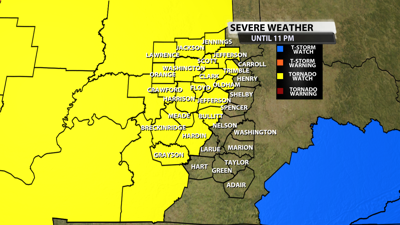

The NWS Storm Prediction Center has issued a
* Tornado Watch for portions of
Central and Southern Illinois
Central and Southern Indiana
Western and Central Kentucky
Far Southeast Missouri
* Effective this Friday afternoon and evening from 300 PM until
1000 PM CDT.
* Primary threats include...
Several tornadoes and a couple intense tornadoes likely
Widespread large hail and scattered very large hail events to
2.5 inches in diameter likely
Widespread damaging winds and isolated significant gusts to 80
mph likely

SUMMARY...Supercells ongoing across eastern MO and western IL are
expected to continue eastward into the destabilizing airmass
downstream across the region. All severe hazards, including very
large hail up to 2.5" to 3" in diameter and strong to intense
tornadoes, are possible.
The tornado watch area is approximately along and 95 statute miles
east and west of a line from 35 miles north northwest of
Indianapolis IN to 40 miles south of Paducah KY. For a complete
depiction of the watch see the associated watch outline update
(WOUS64 KWNS WOU5).
PRECAUTIONARY/PREPAREDNESS ACTIONS...
REMEMBER...A Tornado Watch means conditions are favorable for
tornadoes and severe thunderstorms in and close to the watch
area. Persons in these areas should be on the lookout for
threatening weather conditions and listen for later statements
and possible warnings.


