
The NWS Storm Prediction Center has issued a
* Tornado Watch for portions of
Southern into Central and North-Central Indiana
* Effective this Wednesday afternoon and Thursday morning from
535 PM until 100 AM EDT.
* Primary threats include...
A few tornadoes and a couple intense tornadoes likely
Widespread damaging winds and isolated significant gusts to 80
mph likely
Scattered large hail and isolated very large hail events to 2.5
inches in diameter likely

SUMMARY...Severe thunderstorms are forecast to move east into the
Watch this evening and continue into the early overnight.
Supercells capable of tornadoes, some of which will probably be
strong, large to very large hail, and severe gusts are expected with
this activity.
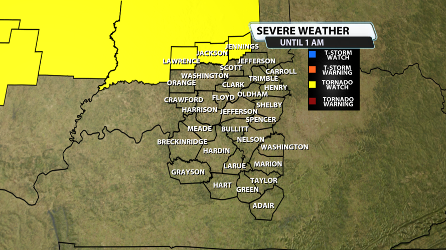
The tornado watch area is approximately along and 70 statute miles
north and south of a line from 25 miles northwest of Terre Haute IN
to 30 miles south southeast of Muncie IN. For a complete depiction
of the watch see the associated watch outline update (WOUS64 KWNS
WOU4).
PRECAUTIONARY/PREPAREDNESS ACTIONS...
REMEMBER...A Tornado Watch means conditions are favorable for
tornadoes and severe thunderstorms in and close to the watch
area. Persons in these areas should be on the lookout for
threatening weather conditions and listen for later statements
and possible warnings.