Rain will change to snow tonight in parts of our area, and we here in the WDRB Weather center have been splitting hairs over our snow map. Where to draw the line between one and two inches of snow, is Louisville half an inch or one and half, who needs to know most of what they'll see is rain, etc. We do that because predicting snow totals is even harder than making a normal forecast, and I'll try to explain why here.
I recorded this video a few years ago during one of our bigger snows to help visualize the difference between several inches of snow and the liquid equivalent of that snow. It was geared toward doing science activities with younger kids, so you can skip ahead about three minutes to get to the explanation of snow ratios that we're focused on today.
Our forecast models are built to predict liquid precipitation, not frozen. Because there are so many different factors that go into a snow forecast, the computer model cannot handle all of that well. We have to look from the surface all the way up to the cloud for temperature and moisture to make sure it’s all saturated and colder than freezing. At the ground, though, the temperature can be a few degrees above 32ºF and you still have snow. Since each of the variables we look for has a little bit of wiggle room, a computer that’s working in 1s and 0s isn’t going to solve that problem very well.
So when we forecast snow, we actually start by forecasting how much liquid water we have to work with. The video above shows that’s a pretty poor stand-in for how much snow can fall. When we talk about snow on TV, you may have heard us describe it as “a wet, fluffy snow” or a “cold, icy” snow. Depending how cold and moist the air is where the snowflakes form, we can get very different kinds of snow to fall. Have you ever seen the snow sparkle? That’s generally a lighter snow that’s made of more ice and less liquid water. When that melts you have even less liquid than with the fluffy, wet snow. We call this a higher snow ratio. If you have 4” of snow, you might only have a few tenths of an inch of liquid water. But if the snow you collect is fluffy and wet, that is a lower snow ratio. If you have 4” of that snow, you might have half an inch or more of liquid water.
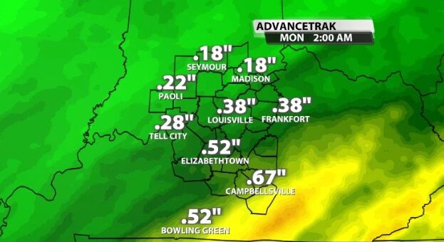
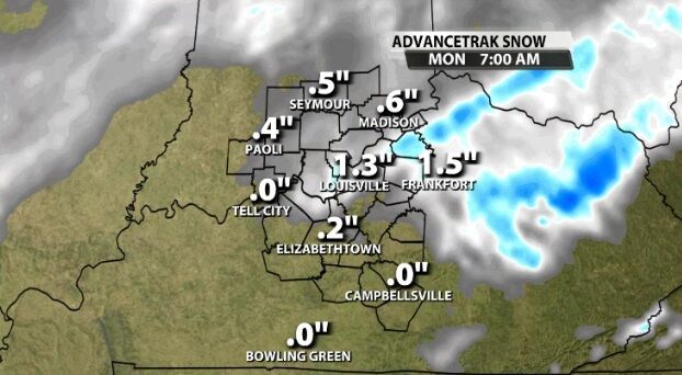
With temperatures so marginal (close to freezing) tonight, this will be a wet snow with a low snow ratio - likely something around 8:1 or 10:1. The images below show how much rain (liquid equivalent) and snow the same forecast model is predicting for this rain/snow mix moving in tonight.


The other problem is that in a situation like the one developing tonight, the snow ratio in New Albany, Indiana, could be pretty different from the one in Frankfort, Kentucky. Please keep in mind the maps above are just one model out of many and only meant to demonstrate the difference between snow and liquid. This is not our forecast for snow or rainfall in our area tonight.


