The sunshine today helped temperatures climb. Louisville hit at least 60 for the high temperature Thursday with most of our area topping out in the upper 50s.
From
To
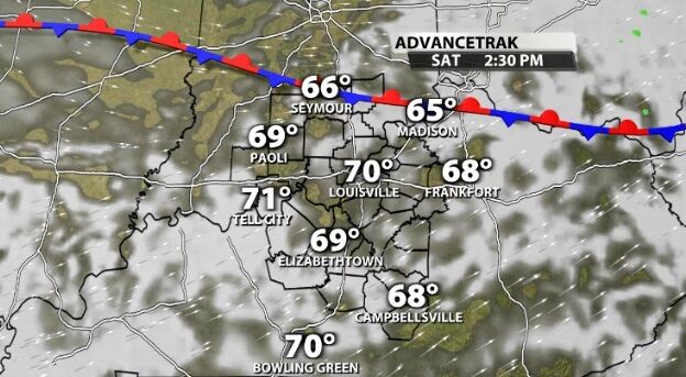
The storms that rolled through overnight came with a strong cold front. Remember a cold front acts like a wall dividing two different kinds of air. Now we are on the cold side of that wall with temperature dropping significantly.

Wow, what a nice weekend we just enjoyed! High temperatures were 5º-10º warmer in the afternoon than the average for this time of year. If you like that "warmer than average" theme, the next two weeks are for you!
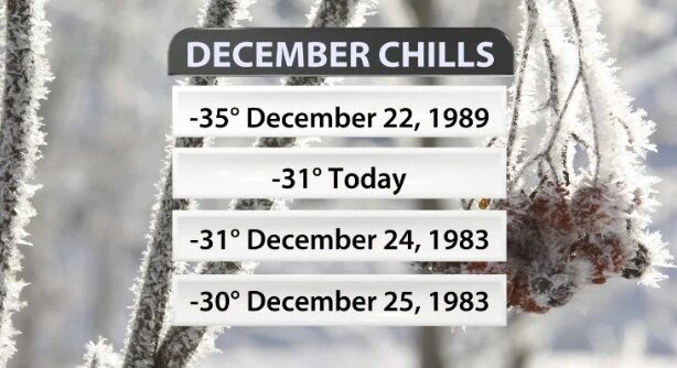
We have now made it through the coldest part of this winter storm! Temperatures (and wind chills) will stay dangerously low, but it does slowly get better from here. We all know this system brought crazy cold air, but you might be surprised at how some of these statistics stack up!

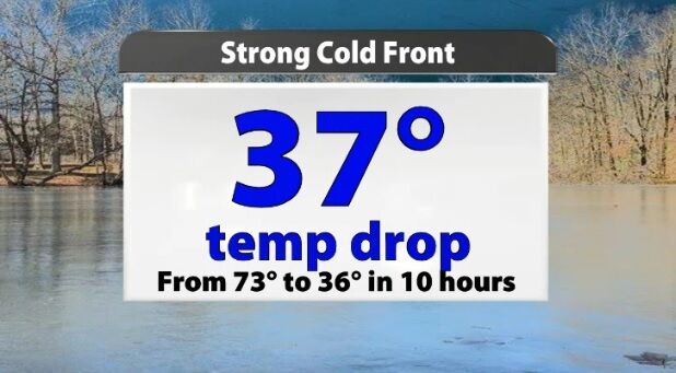
After the last few days have brought lots of sunshine and high temperatures near 80, this cold front is bringing a noticeable drop in temperature. It's not the only one in the next week either.
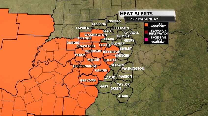
A new Heat Advisory has been issued from Noon til 7 PM (Eastern) Sunday for areas highlighted below in orange. A Heat Advisory means the temperature and humidity will be high enough as to be hazardous to your health.

Sunday was the first day in a while we've had to talk about the heat index being so much higher than the temperature, and there was a lot of misinformation about it on social media. Today we will look at how heat index is calculated, what it means, and how you should use that information.

Company officials did not release any information regarding employees who have tested positive "out of respect for the families," according to a news release.

A recent report from NASA shows 2019 was the second warmest year globally on record. The only year warmer than 2019 was 2016.

Top Story
Several people took advantage of Louisville's warm weather on Christmas Day and spent time outside. According to the National Weather Service's Louisville office, the city broke a Christmas record this year, hitting 69 degrees.