
22 out of 31 July days had high temperatures in the 90s in Louisville. Generally temperatures start to dip slightly in August, so you can look forward to that in our August outlook. Looking through climate data, the average high temperature for July is 88.7º and is 88.3º for August. That's barely a difference, but it tells us by the end of July we have normally seen the worst of the heat.
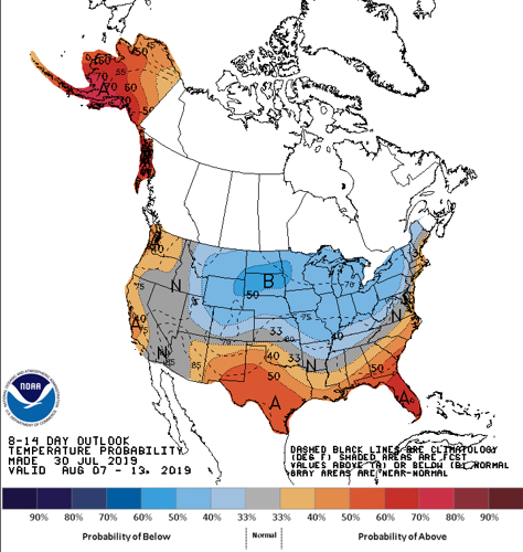
TEMPERATURE
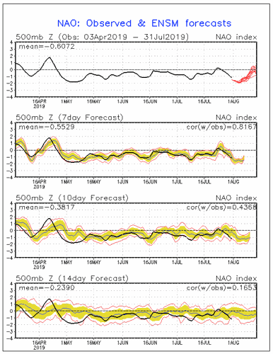
The biggest influence on your outlook, especially through the first half of the month, is the North Atlantic Oscillation. The NAO is a teleconnection that has a major impact on our weather. A teleconnection is a large scale pressure change in one place that leads to a change in wind pattern and thus influences change in temperature and/or precipitation somewhere else. For example, the NAO describes a pressure change over Greenland and another one over the central Atlantic, but it will change our temperature pattern here in Kentuckiana.

NAO has generally been negative for several months meaning a generally cooler Eastern United States. The negative NAO sets up a block in the north Atlantic creating a trough in Eastern Canada. We need that block to be particularly strong for it to influence us this time of year. Now NAO is trending positive, but it may be a short-lived positive. The graph at the bottom of the picture above looks farthest into the future, and it shows the NAO likely to turn negative again by the end of August. So a quick positive turn before going back negative likely brings us a quick warm-up early in the month before temperatures return closer to normal toward the middle of August.

PRECIPITATION
When looking for pattern changes that would affect our rain chances, there is not much to tell. I see no real pattern flips or flow changes that alter our precip pattern, so I would expect a fairly normal August in terms of rain.
It's worth noting with the flow pattern influenced by a negative NAO, we will likely see more northwesterly flow which doesn't bring us a lot of rain. Flow from a more humid region, like the southeast, is more likely to set up a wet pattern. The exception to that would be if any tropical systems move toward us in August, but even that seems unlikely. With a trough in eastern Canada and the northeast United States, the jet stream would likely curve a tropical system that made it inland back to the east away from us.
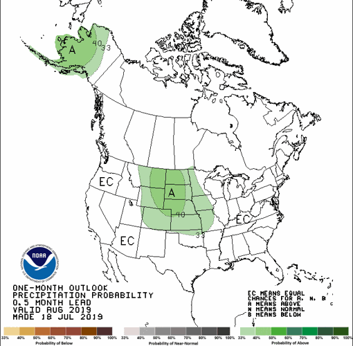
The Climate Prediction Center's precipitation outlook for August shows Equal Chances (EC) for either a wet or dry month, suggesting they agree we will likely be near normal. We will start dry, so that will cut in to our overall number, but normal rainfall in August is 3.33" in Louisville.

Please note: long-range forecasting like this is one of the most difficult forecasts to make because so much can and will change between now and the middle of August, even more so by the end of the month. This discussion should advise you about patterns setting up, not specific high temperatures and rain totals to expect.


