Normally in the winter you read a lot online the polar vortex or hear people talk about the fact that it's headed your way. That seems to be largely missing this winter, so let's talk about why.
What is the Polar Vortex?
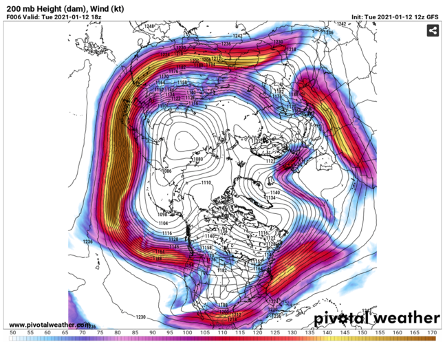
First let's start by clearing up what the Polar Vortex (PV) is and is not. The PV is a semi-permanent upper-level low pressure centered generally around the north pole. That means it's really always there whether or not we're regularly talking about it in your forecast. The cold air in this wind pattern is actually swirling in the low stratosphere, which is miles above our head. This is a view of the Polar Vortex today (Tuesday, January 12):

What the Polar Vortex is not:
- a storm system here at the ground
- coming for you or going to hit your house
- a scary, spinning monster
Where is the Polar Vortex now?
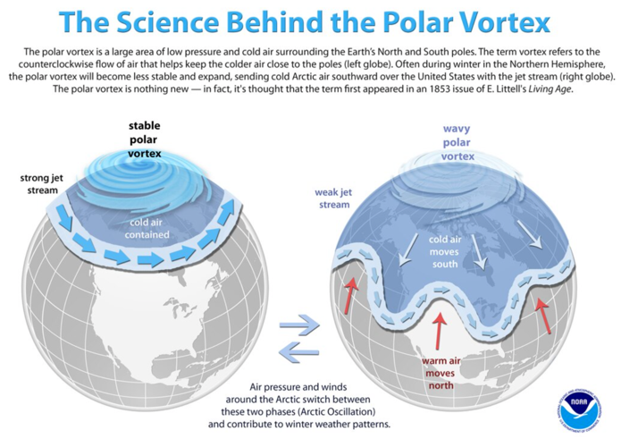
Take another look at the image above. That's where the PV is right now, but it doesn't look quite right. It should be a much tighter, smoother circle centered closer to the pole. Warm air (also called "ridging") has knocked the vortex off its normal track. This kind of stratospheric warming happens every couple of years, and can displace the PV like this. When the pattern starts to get more wavy like this, the Polar Vortex will likely break off into smaller pieces and drop cold air in a few spots across the northern hemisphere. The image below from NOAA does a great job showing you those differences!

The breaking off of part of the vortex is what defines a polar vortex event here, but it actually occurs when the vortex is weaker not stronger. That might sound weird—but it actually makes sense. Normally, when the vortex is strong and healthy, it helps keep a current of air known as the jet stream traveling around the globe in a pretty circular path. This current keeps the cold air up north and the warm air down south. Without that strong low-pressure system, the jet stream doesn’t have much to keep it in line so it becomes wavy and meandering. Put a couple of areas of high-pressure in its way, and all of a sudden you have a river of cold air being pushed down south.
What does that mean for us?
Keep in mind, the polar vortex doesn't come down here to the ground. The PV wind pattern influences the jet stream just a little lower in the atmosphere which drives our weather patterns here at the surface. When that happens we talk about a "displacement" of the polar vortex affecting your forecast.
When we see pieces break off from the PV, it doesn't necessarily mean either warmer or colder air for us. If one of those pieces becomes displaced near us, that would bring colder air. But if it settles in over the Pacific Northwest, that would mean warmer air for us. It really just means that your temperatures are still volatile and will likely still be pretty up-and-down for the next several weeks.


