
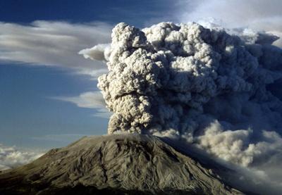
Today in science: On May 18, 1980, Mount St. Helens underwent a catastrophic and deadly eruption, triggering the largest landslide ever recorded. Earlier in the year, thousands of small earthquakes, venting steam, and a growing bulge protruding 450 feet (140 m) indicated that magma was rising in the volcano. Then, at 8:32 a.m. local time 41 years ago today, a 5.1-magnitude earthquake rocked the mountain, triggering the huge landslide and lateral blast that collapsed the volcano’s northern face. Hot pressurized magma erupted, and the ash plume reached a towering height of 80,000 feet (15 miles, 24 km), before blanketing the surrounding region. A Unites States Geological Survey (USGS) geologist described the destructive blast:
It completely destroyed an area of 230 square miles in a matter of five to nine minutes. It essentially killed everything within that area.
Fifty-seven people, including volcanologist David A. Johnston and photojournalist Reid Blackburn, were killed during the May 18, 1980, eruption at Mount St. Helens. The Johnston Ridge Observatory in Toutle, Washington, was named for the late volcanologist. As of May 10, 2021, while the Observatory itself is closed with no firm opening date, the plaza area behind the building with an incredible view of the crater and volcano, and blast zone, is open.
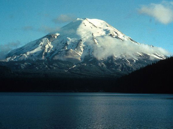
Before: Mount St. Helens photographed seven years prior to the 1980 eruption. Image via U.S. Forest Service/ eruptionbook.com.
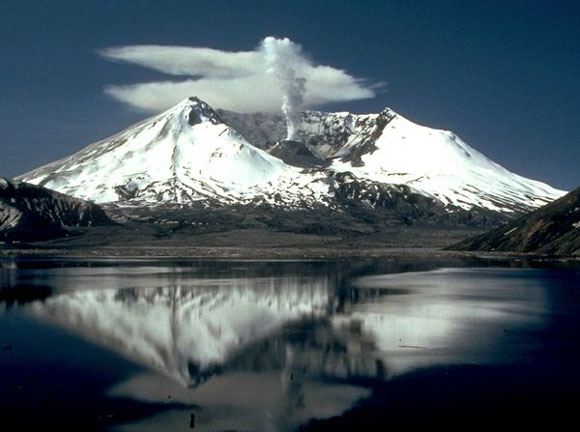
After: Mount St. Helens photographed two years after the 1980 eruption. Image via Lyn Topinka/ USGS.
The dense forest that covered the slopes of the volcano was reduced to ash inside an area known as the inner blast zone, which extended about 6.2 miles (10 km) from the summit. Trees farther away from the inner blast zone were also damaged by the searing heat. The total extent of the devastated forested area is known as the blowdown zone. Over the past decades, this area has slowly rebounded with life.
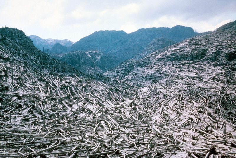
This aerial view of timber blowdown was taken on June 8, 1980, after it was leveled by the Mount St. Helens eruption. Image via USGS/ Geoengineer.org.
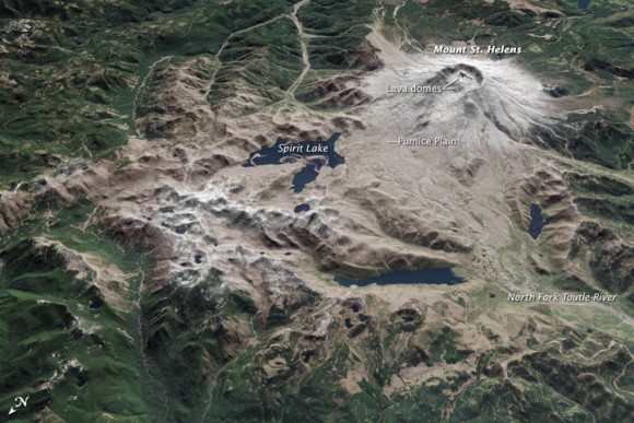
Mount St. Helens on April 20, 2015. Read more about this image at NASA Earth Observatory. Image via NASA Earth Observatory.
Lahars – mudflows carrying debris from volcanic eruptions – formed rapidly from the melting ice and snow on Mount St. Helens’s flanks. The massive lahars created in the 1980 eruption damaged homes, roads and bridges in nearby communities.
Article Courtesy of EarthSky.org
Timeline
March 16, 1980
The first sign of activity occurred as a series of small earthquakes.
March 27, 1980
The volcano has its "first eruption in over 100 years." Steam explosions blasted a 200- 250 ft wide crater through the volcano's summit ice cap and covered the snow-clad southeast sector with dark ash.
March 27 to April 22, 1980
Eruptions occurred on average from about 1 per hour in March to about 1 per day by April 22 when the first period of activity ceased.
May 7 to May 17, 1980
Small eruptions resumed on May 7 and continued to May 17. By that time, more than 10,000 earthquakes had shaken the volcano and the north flank had grown outward about 450 ft to form a prominent bulge.
May 18, 1980
8:32 am - A magnitude 5.1 earthquake occurred causing a "massive landslide" on the northern side, followed by a lateral blast. The debris avalanche swept around and up ridges to the north, but most of it turned westward traveling as far as 14 miles down the valley of the North Fork Toutle River. The landslide removed part of the cryptodome (a very hot and highly pressurized body of magma), triggering powerful eruptions that blasted laterally through the sliding debris. As the lateral blast of hot material overtook the debris avalanche; it accelerated to at least 300 mi per hr. Within a few minutes an eruption cloud of blast tephra began to rise from the former summit crater, quickly reaching 15 miles high.
12:15 pm - Beginning just after noon, the volcano entered the "Plinian phase" which continued for the next 9 hours producing a high eruption column, numerous pyroclastic flows, and ash fall downwind of the eruption. The pyroclastic flows reached speeds of 50 to 80 mi/hr and spread as far as 5 miles to the north. Scientists estimate that the eruption reached its peak between 3:00 and 5:00 p.m.
Over the course of the day, winds blew 520 million tons of ash eastward across the United States. Complete darkness occurred in Spokane, WA almost 250 miles from the volcano. Major ash falls occurred as far away as central Montana and in the Great Plains of the Central United States, more than 930 miles away. The ash cloud spread across the U.S. in three days and circled the Earth in 15 days.
May 25, June 12, July 22, Aug 7, Oct 16-18, 1980
The volcano has "smaller explosive episodes," each of which produced eruption columns 8-9 miles above sea level and pyroclastic flows down the volcano's north flank.
1980 to 1986
Beginning in October 1980, episodic eruptions built a new lava dome that reached nearly 1000 ft above the crater floor. Minor explosive activity, and sometimes lahars (a mixture of water and volcanic debris that moves rapidly downstream), accompanied several of the 1981 to 1986 episodes. In addition to the 17 dome-building episodes, hundreds of small explosions of gas and steam occurred, sending ash a few hundred feet to several miles above the volcano.
1989 - 1991
Between August 1989 and October 1991, at least six small ash-producing explosions occurred from the Mount St. Helens dome complex. Several of the explosions were accompanied by avalanches of snow and rock, pyroclastic density flows, ballistic projectiles, and debris flows.
Sources: USGS Volcano Hazards Program: 1980 Cataclysmic Eruption and USGS Scientific Investigations Report 2017–5022–C


