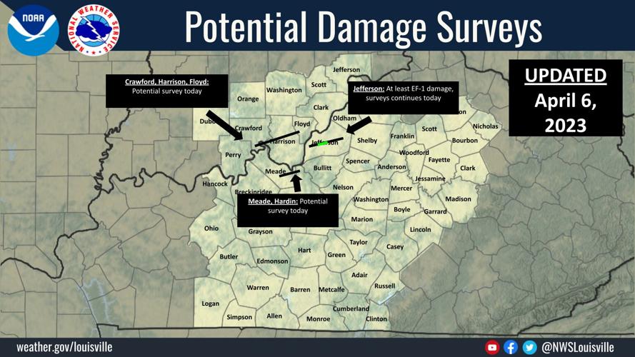


Wednesday night tornadoes and elite-level wind caused damage in our area. The National Weather Service employees in Louisville have been surveying the damage done to see if it was caused by a tornado or by straight-line wind. They then determine how strong the wind or tornado was based on the damage it did. Here are the results of what they found:
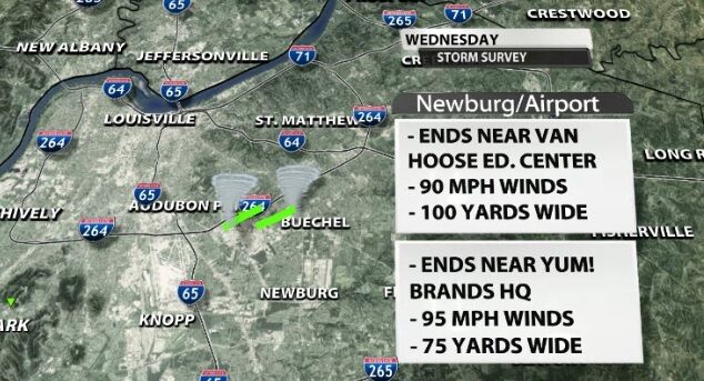
In the Newburg area and communities near the Louisville airport, two EF-1 tornadoes touched down. The one with maximum winds of 90 mph took a path that started south of the Newburg post office and ended near the Van Hoose Education Center. At its widest, that tornado was the size of a football field.
The second tornado in that area started just east of the post office and ended near Yum! Brands headquarters. This tornado maxed out at 75 yards wide and 95 mph winds. The surveys for both of these tornadoes remain preliminary.
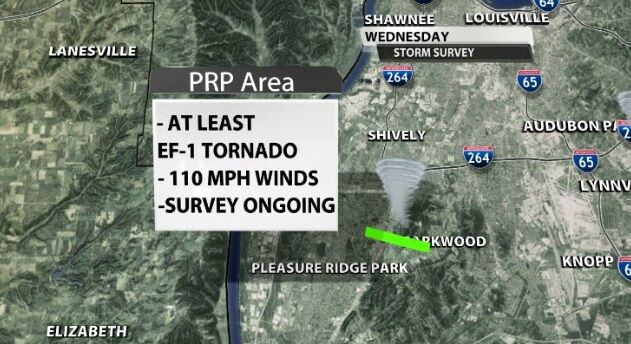
Some of the worst damage images coming in have been from the Pleasure Ridge Park area in southwestern Jefferson county. A tornado of at least EF-1 strength touched down there with winds up to 110 mph. That survey remains ongoing as well.
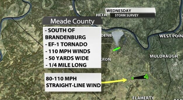
In Meade county another EF-1 tornado touched down with maximum 110 mph gusts. It was on the ground for a little more than a quarter of a mile, and was 50 yards wide at its widest. This survey has concluded; here's what the weather service employees observed that led them to rate this a high-level EF-1:
THE NATIONAL WEATHER SERVICE IN LOUISVILLE CONDUCTED A STORM
SURVEY OF DAMAGE THAT OCCURRED JUST SOUTH OF BRANDENBURG NEAR THE
INTERSECTION OF BRANDENBURG ROAD, PICKETT DRIVE AND CEDAR LINE
COURT. THE TORNADO FIRST TOUCHED DOWN NEAR PICKETT DRIVE WHERE
EXTENSIVE TREE DAMAGE WAS OBSERVED. SEVERAL CEDAR TREES WERE
UPROOTED OR SNAPPED BETWEEN 10 AND 20 FEET IN HEIGHT. MOST OF THE
TREE DAMAGE WAS OBSERVED TOWARD THE NORTH AND NORTHEAST
DIRECTIONS, ALTHOUGH THERE WAS SOME OTHER TREE DAMAGE THAT WAS
DIRECTLY FACING EAST SUGGESTING A CONVERGENCE OF WINDS TOWARDS
HOMES ALONG PICKET AND CEDAR LINE ROAD. SIGNIFICANT ROOF DAMAGE
WAS ALSO OBSERVED ALONG PICKETT DRIVE, INCLUDING DAMAGE TO
OUTBUILDINGS. THE TORNADO THEN CROSSED JOE PRATHER HIGHWAY
(BRANDENBURG ROAD) TOWARD CEDAR LINE COURT, WHERE MORE TREE DAMAGE
AND MINOR DAMAGE TO HOMES OCCURRED. HOME VIDEO SHARED ALSO SHOWED
A CIRCULAR PATTERN TO DAMAGE THAT OCCURRED WHEN THE STORM PASSED,
FURTHER CONFIRMING THAT THE DAMAGE WAS CAUSED BY A TORNADO. THE
TORNADO QUICKLY DISSIPATED AFTER HOME DAMAGE WAS OBSERVED ALONG
CEDAR LINE COURT AS NO FURTHER DAMAGE WAS OBSERVED BEYOND THE
NEARBY FARM FIELD.
Additionally, in Meade county between Garrett and Grahamton, there was damage caused by straight-line winds between 80 and 100 mph. This is what the NWS employees observed in that area:
THE NATIONAL WEATHER SERVICE CONDUCTED A STORM SURVEY OF A SEVERE
THUNDERSTORM THAT CAUSED DAMAGE ALONG US HIGHWAY 60 (OWENSBORO
HIGHWAY). DAMAGE WAS FIRST OBSERVED ALONG HOGWALLOW LANE WHERE
TRACTOR TRAILERS WERE BLOWN OVER ALONG THE ROADWAY. SNAPPED AND
UPROOTED TREE DAMAGE WAS OBSERVED AT SEVERAL HOMES HEADED EASTWARD
ALONG US HIGHWAY 60. THE MOST EXTENSIVE DAMAGE WAS OBSERVED ALONG
TIPTOP ROAD, WHERE A CAMPER WAS BLOWN OVER ALONG WITH EXTENSIVE
TREE DAMAGE. A GARAGE OUTBUILDING ALSO HAD SEVERAL PANELS BLOWN
OFF IN THE NORTHEAST DIRECTION. TREE DAMAGE WAS ALSO OBSERVED
ALONG ROBBINS DRIVE AND FINCH COURT, INCLUDING COMPLETE
DESTRUCTION OF SEVERAL CAR PORTS. ALL DAMAGE WAS IN THE
NORTHEASTERLY DIRECTION AND APPEARED TO BECOME MORE WIDESPREAD
TOWARD THE END OF THE DAMAGE PATH, WHICH IS MORE INDICATIVE OF
STRAIGHT LINE WIND DAMAGE. ESTIMATED MAX WIND SPEEDS ALONG THE
PATH FROM DAMAGE RANGED BETWEEN 80 MPH AND 100 MPH.
A survey is also planned for Harrison county, Indiana, but the teams didn't make it there today. That will include any damage around Corydon.

This post will be updated as we get more information from the National Weather Service.
Related stories:
- Powerful winds, 2 tornadoes, leave path of destruction in Louisville's Newburg neighborhood
- 3 tornadoes confirmed in Louisville, 1 in Meade County
- National Weather Service confirms EF-1 tornado in Meade County
- Residents in Corydon, Ind. rebuilding after storms rip down trees, power lines
- IMAGES | Damage and debris from Louisville and surrounding areas after violent storms
- Newburg area hit by EF-1 tornado Wednesday, National Weather Service reports
- Thousands without power in Kentuckiana after severe storms Wednesday afternoon
- About 50 people displaced after heavy winds damage south Louisville apartment complex
- IMAGES | Wind and weather damage from April 5, 2023 storms


