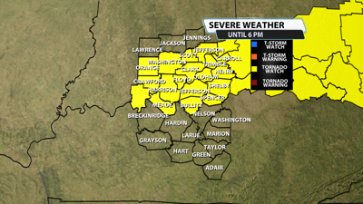


The NWS Storm Prediction Center has issued a
* Tornado Watch for portions of
Southern Indiana
Northern Kentucky
Southern Ohio
* Effective this Wednesday afternoon and evening from NOON until
600 PM EDT.
* Primary threats include...
A couple tornadoes possible
Scattered damaging wind gusts to 70 mph possible
Isolated large hail events to 1.5 inches in diameter possible
SUMMARY...Developing thunderstorms may pose some threat for a couple
of tornadoes and damaging winds as they move quickly eastward
through the afternoon. Isolated hail may also occur if a supercell
can develop and be sustained.
The tornado watch area is approximately along and 25 statute miles
north and south of a line from 30 miles west of Louisville KY to 170
miles east northeast of Louisville KY. For a complete depiction of
the watch see the associated watch outline update (WOUS64 KWNS
WOU3).
PRECAUTIONARY/PREPAREDNESS ACTIONS...
REMEMBER...A Tornado Watch means conditions are favorable for
tornadoes and severe thunderstorms in and close to the watch
area. Persons in these areas should be on the lookout for
threatening weather conditions and listen for later statements
and possible warnings.


