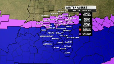


Our Winter Storm Warning has been expanded a few counties north to now include Metro Louisville, Harrison Co, and Shelby Co. The counties that were already included in the Winter Storm Warning still remain in it, starting at 7PM this evening through 12PM Wednesday.

Most of our Indiana counties are still included in a Winter Weather Advisory for the same timeframe as the Winter Storm Warning.
Here's the newest details on the Winter Storm Warning for the counties just added from the NWS:
- WHAT...Heavy snow expected. Total snow accumulations of 3 to 5 inches.
- WHERE...Portions of south central Indiana and east central and north central Kentucky.
- WHEN...From 7 PM this evening to noon EST Wednesday.
- IMPACTS...Plan on slippery road conditions. The hazardous conditions could impact the Wednesday morning commute.
Here's the details for the counties that were already included in the winter storm warning prior to it being extended:
- WHAT...Heavy snow expected. Total snow accumulations of 3 to 6 inches with locally higher amounts.
- WHERE...Portions of Indiana and east central, north central, northwest, and south central Kentucky.
- WHEN...From 6 PM CST /7 PM EST/ this evening to 11 AM CST /noon EST/ Wednesday.
- IMPACTS...Plan on slippery road conditions. The hazardous conditions could impact the Wednesday morning commute.
Lastly, here's a refresher on the details for those included in the winter weather advisory in Indiana:
- WINTER WEATHER ADVISORY REMAINS IN EFFECT FROM 7 PM THIS EVENING TO NOON EST WEDNESDAY...
- WHAT...Snow expected. Total snow accumulations of 2 to 3 inches.
- WHERE...Portions of south central Indiana and east central and north central Kentucky.
- WHEN...From 7 PM this evening to noon EST Wednesday.
- IMPACTS...Plan on slippery road conditions.
- The hazardous conditions could impact the Wednesday morning commute.
We will have our latest snow totals map from the WDRB Weather Team online in our blog later this afternoon and on WDRB News starting at 4pm.
Related Stories:


