No one on the bus was injured.
No one on the bus was injured.
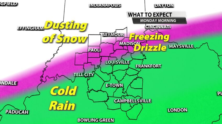
A wintry mix of freezing rain and snow is moving our direction from the southwest. This mix will move into our area this afternoon, and we will see snow spread across more of the area tonight.
The week ahead brings rounds of wintry mix to our area, potentially icy mix. While on their own none of these will be a major winter storm for our area, each will bring different impacts to our communities. That's what we will walk through here: the timing of these early rounds and what impacts they bring to which areas.
The National Weather Service hosted a conference call for their partners Wednesday afternoon to discuss the winter storm that will start to impact us Thursday.
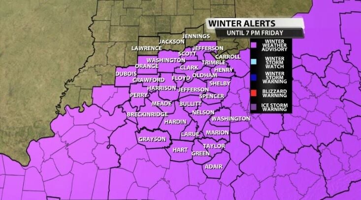
During the winter season, we get a lot of weather alerts from the National Weather Service. You have probably heard us talk about Ice Storm Warnings, Winter Weather Advisories, and even Winter Storm Watches. Each of our winter alerts means something slightly different, so let's make sure we are on the same page when it comes to these winter threats.
In Kentuckiana, we see all different kinds of weather and precipitation types. We get it all from severe thunderstorms to blizzards! We will see snow, rain, sleet, freezing rain, graupel, and hail...but what is the difference between all of these main precipitation types? Let's explain!

Here in the Ohio Valley we get all types of winter weather. We have snow, we get sleet, and we get freezing rain, so let's go ahead and talk about how each of those happens.
Tuesday afternoon the National Weather Service office in Louisville hosted a conference call for their partners to discuss the next round of winter weather. While this call is actually about the next storm, we started with a brief discussion of why the forecast for Tuesday didn't pan out exactly as expected
The snow, sleet, and freezing rain have now blanketed our area. We are in the midst of the second round of winter weather coming from this storm. This post is a "nowcast" - what we are seeing now and how it affects the forecast through the rest of the evening.

Kentucky’s largest school district canceled winter sports events Wednesday evening with winter weather expected.