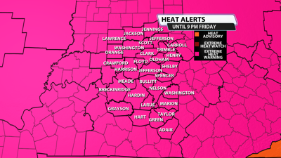

I hope you are staying cool and hydrated through this intense heat wave. While the individual days may come up a little short of criteria, who cares? The cumulative effect of day after day with heat index values in the triple digits is dangerous. Today is our 2nd day in the 90's and we still have 6 more to go. Lawrence, Jackson, Jennings and Carroll counties are now under the Extreme Heat Warning until Thursday at 8 pm. That's the expansion. The rest of our area, including Louisville, has seen an extension to the warning until Friday at 9 pm.

...EXTREME HEAT WARNING NOW IN EFFECT UNTIL 9 PM EDT /8 PM CDT/
FRIDAY...
* WHAT...Dangerously hot conditions with peak heat index values
between 100 and 115 degrees Fahrenheit. Mild overnight
temperatures will also not allow for much reprieve from the hot
and humid conditions.
* WHERE...Portions of south central Indiana and east central, north
central, northwest, and south central Kentucky.
* WHEN...Until 9 PM EDT /8 PM CDT/ Friday.
* IMPACTS...Heat related illnesses increase significantly during
extreme heat and high humidity events.
PRECAUTIONARY/PREPAREDNESS ACTIONS...
Drink plenty of fluids, stay in an air-conditioned room, stay out of
the sun, and check up on relatives and neighbors.
Do not leave young children and pets in unattended vehicles. Car
interiors will reach lethal temperatures in a matter of minutes.
Take extra precautions when outside. Wear lightweight and loose
fitting clothing. Try to limit strenuous activities to early morning
or evening. Take action when you see symptoms of heat exhaustion and
heat stroke.


