
When the first advisories were issued, the National Hurricane Center talked about low pressure in Kentucky leading to potential tropical development. Now that low pressure is over Georgia, and it is more likely that will create some tropical activity in the Gulf.
So how does this happen? How does low pressure in Kentucky become tropical? It's more of a chain reaction than the low moving straight from Kentucky to the Gulf of Mexico. In the discussion below, the NHC forecaster references a trough of low pressure that has moved from western Kentucky toward Georgia in the last couple days. That trough will help lower pressure in the northern Gulf as it moves south. As the pressure drops (a result of that trough), a center of low pressure will likely form in the northern Gulf. That low will be able to strengthen, potentially to a tropical depression, with the warm Gulf water to fuel it.

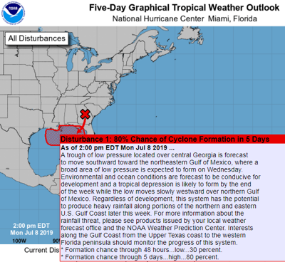
While this is now likely to become a tropical depression by the weekend, rainfall is the main concern. Whether or not this storm gets a name, it will dump a lot of rain on the Gulf coast region over the weekend. If it does strengthen enough to earn a name, this would be Tropical Storm Barry. Below is the text from the Advisory issued by the National Hurricane Center. It is the same text in the image above.
A trough of low pressure located over central Georgia is forecast
to move southward toward the northeastern Gulf of Mexico, where a
broad area of low pressure is expected to form on Wednesday.
Environmental and ocean conditions are forecast to be conducive for
development and a tropical depression is likely to form by the end
of the week while the low moves slowly westward over northern Gulf
of Mexico. Regardless of development, this system has the potential
to produce heavy rainfall along portions of the northern and eastern
U.S. Gulf Coast later this week.  For more information about the
rainfall threat, please see products issued by your local weather
forecast office and the NOAA Weather Prediction Center.  Interests
along the Gulf Coast from the Upper Texas coast to the western
Florida peninsula should monitor the progress of this system.
* Formation chance through 48 hours...low...30 percent.
* Formation chance through 5 days...high...80 percent.


