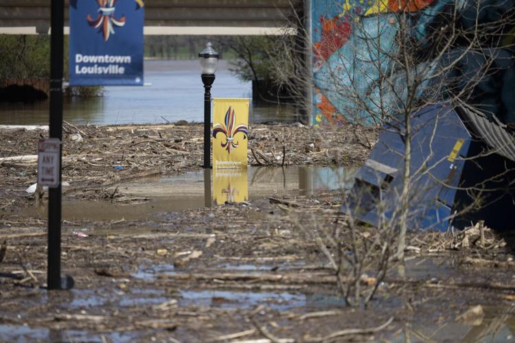


LOUISVILLE, Ky. (WDRB) -- Nearly a week of widespread heavy rain caused flooding across Kentucky and southern Indiana, putting feet of water in homes and businesses and sparking evacuations in several small towns near the Kentucky River.
There is a lot of information to share, so we will update this story with the latest information coming into the newsroom. Check back for updates:
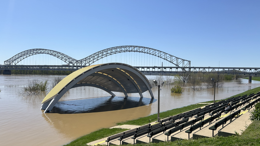
Waterfront Park community flood cleanup
Friday, April 11 | 10 a.m.
Waterfront Park is organizing a community cleanup day and is looking for volunteers.
As the Ohio River begins to recede, trash and other debris will be left behind. The cleanup effort will "help restore this shared space to a welcoming site."
Cleanup will take place Saturday, April 12, from 9 a.m. to 12 p.m. on the Great Lawn at 231 Witherspoon Street. That's near the intersection of Witherspoon and Floyd streets.
Free parking will be available in the surface lot across from the Great Lawn. Because some surrounding roads will still be flooded and closed, organizers said volunteers should access Waterfront Park from Main Street. Waterfront Park said volunteers can ride to the cleanup via Bird scooter, with two free rides available using code "waterfront."
Park staff will also be on hand. Supplies, including trash bags, gloves and pinchers, will be provided.
Those volunteering should plan on wearing long pants, sturdy closed-toe shoes or rubber boots, as well as rubber gloves if they have them. Water bottles are also encouraged.
Anyone interested in volunteering is asked to sign up in advance. Volunteers will check in and sign waivers upon arrival to get supplies.
To sign up, click here.
FEMA offering help to Kentuckians cleaning up after flooding
FEMA is offering volunteer help to those picking up after historic flooding across Kentucky. Homeowners and renters who saw damage between April 2 and April 7 can ask for help.
Volunteers will help clean up, take out damaged walls (drywall), cover roofs, pick up debris, stop mold from growing, and remove broken appliances.
Those needing help can call the volunteer hotline at 1-502-607-6665. Operators are available from 8 a.m. to 8 p.m. (eastern), but voicemails can be left after hours.
Hardin County supply drive
Thursday, April 10 | 6:20 p.m.
The Hardin County Sheriff's Office is asking for help collecting donations for flood cleanup.
Some of the items needed include:
- Heavy duty trash bags (contractor bags preferred)
- Large bottles of bleach
- Disinfectant cleaners (Lysol, Clorox, Pine Sol)
- All-purpose cleaners
- Mold and mildew removers
- Heavy duty sponges
- Scrub brushes of various sizes
- Buckets (5-gallon and smaller)
- Mops (sponge mops or heavy duty string mops)
- Brooms and dustpans
- Squeegees
- Shop towels/heavy duty cleaning cloths
- Microfiber cloths
- Magic Erasers
- Paper towels
- Disposable gloves (nitrile or latex)
- Heavy duty reusable gloves for tougher jobs
- Face masks (preferably N-95 masks)
- Safety goggles or glasses
- Hand sanitizer
- Air fresheners or odor neutralizers (DampRid or Febreze)
The sheriff's office said clothing is not needed at this time.
Donations can be dropped off any day between 8 a.m. and 4:30 p.m. at the Hardin County Clerk's Office on North Provident Way in Elizabethtown. There will be a drop-off location set up at the lower level entrance on the back of the building.
Free tetanus vaccines for Bullitt County first responders
Friday, April 11 | 8:45 a.m.
The Bullitt County Health Department is offering free tetanus vaccines for first responders and those involved in flood cleanup who are over the age of 19.
The vaccine will only be given to those individuals. The health department said flood conditions present an increased risk of injuries like cuts and puncture wounds, which can allow tetanus bacteria to enter someone's body.
The mobile vaccine clinic is scheduled for Monday, April 14, from 10 a.m. to 2 p.m. at Lebanon Junction City Hall on Main Street.
The vaccines are free and no appointment is needed.
For more information, click here.
West Point flood update
Friday, April 11 | 11 a.m.
- Supplies will be available at the school Friday, April 11 from 10 a.m. to 2 p.m. and 5-7 p.m.
- Free electrical inspections will begin Saturday, April 12 at 9 a.m. If you will be ready for one by then, text "INSPECTION" with your address to 502-216-3455 and the inspector will get there as soon as possible. There will be two LG&E crews in town 12 hours Saturday and Sunday.
- There will be an extra food truck for lunch Friday, April 11 to reduce wait times.
- They're compiling a list of those who need help cleaning up and those who want to help clean up. If either applies, text "NEED HELP" or "WILL HELP" to 502-216-3455.
How to avoid injury or infection
Wednesday, April 9 | 10 p.m.
As people wait to get back into flooded homes, public health experts are reminding residents to make their health and safety a top priority.
From sharp objects to sewage, mold and bacteria — what's hiding beneath the floodwaters is anyone's guess. That's why is a good idea to get a tetanus shot before beginning the process of cleaning up.
Also remember to wear protective gear, like rubber boots, gloves and masks.
As for what to keep and what to throw away, the Environmental Protection Agency said after a flood, you can clean or dry anything that doesn't absorb water. That includes metal or plastic furniture, dishes, jewelry and glass.
You'll want to toss out things like mattresses, upholstered furniture, cushions, medicine and wood veneer furniture.
In southern Indiana, Clark County health officials suggest avoiding or limiting direct contact with contaminated floodwaters, to wash your hands frequently with soap, especially before drinking and eating. Do not allow children to play in floodwater or allow them to play with toys contaminated with floodwater. Cuts or open wounds should be reported, as well as symptoms of illness.
Louisville Water service won't be impacted by flooding
Wednesday, April 9 | 8:39 p.m.
Louisville Water said Wednesday evening it didn't anticipate any interruptions to water service as the city experiences historic flooding.
However the agency said it has made "a few" adjustments to operations. Those include putting protocols in place for "higher turbidity," cloudiness or haziness, in the Ohio River, and pausing the Residual Line Project along River Road. That crew, Louisville Water said, will stay at the Water Tower pumping station where they will be able to maintain equipment and monitor operations.
Crew members, who work 24-hour shifts, are being taken to and from the pumping station by boat with the help of Louisville Fire and Rescue.
For more information about what the water company is doing and how they're making sure service continues as usual, click here.
Clark County, Indiana, flood recovery resources
Wednesday, April 9 | 3:09 p.m.
Contact IN211 to report damages and needs at IN211.org or 866-211-9966. If your area has experienced flooding and needs recovery assistance, please contact Indiana 211 at 866-211-9966 or online at in211.org, or the Clark County Emergency Operations Center at 812-252-4195. If you have an emergency, please dial 911.
Utica
- Shelter: American Red Cross Shelter (Open 24/7) and meals provided at Utica United, 605 Old Salem Road, Utica, IN.
- Meals (Saturday–Monday) by the Salvation Army with breakfast, lunch and dinner provided at Utica Preservation Association/Community Center, 106 N. 4th Street, Utica, IN.
- Cleaning kits available at the Utica Preservation Association/Community Center, 106 N. 4th Street; Bushmans Clubhouse and Rodney's on Stoneview Drive
- Medical Services (Saturday–Monday, 9 a.m. – 6 p.m.) with first aid, immunizations and basic medical care provided by the Clark County Health Department Mobile Health Trailer at Utica Church of Christ, 300 S. 4th Street, Utica, IN.
- Medical Services (Saturday–Sunday, 9 a.m. – 6 p.m.) with first aid, immunizations and basic medical care provided by Clark County Health Department Mobile Unit at Bushmans – Rivers Edge.
Jeffersonville/Clarksville/Sellersburg
- Mobile Medical Services (Saturday and Sunday, 10 a.m. - 2 p.m.) at the Clark County Health Department, 1201 Wall Street, Jeffersonville.
- Cleaning kits are available to residents impacted by flooding.
For the latest updates, check the Clark County Emergency Management Agency - Indiana Facebook page, here.
FEMA on the ground in Frankfort
Wednesday, April 9 | 4:30 p.m.
FEMA has a mobile emergency response unit on the ground in Frankfort after President Donald Trump signed a disaster declaration for Kentucky that covers last week's tornadoes and flooding that has followed in the week since.
The declaration opens up federal assistance to help cities repair infrastructure.
Kroger flood relief campaign
Wednesday, April 9 | 3:30 p.m.
Kroger is offering shoppers the chance to help their neighbors affected by the historic flooding across Kentuckiana.
Kroger and Jay C locations in Kentucky and southern Indiana are donating money to support flooding victims. At checkout, guests will be asked if they want to round up their total to the nearest dollar. Donations of any monetary amount will also be accepted at checkout.
All money raised through these donations will be sent to the Red Cross.
The flood relief campaign is happening now and runs through Saturday, May 3.
Blackiston Mill Road Bridge in Clarksville covered by floodwaters
Wednesday, April 9 | 9 p.m.
In southern Indiana, the heavily traveled bridge connecting New Albany and Clarksville is completely covered by floodwaters from Silver Creek underneath it. Areas of grass near the bridge are now completely covered by water.
But the bridge and the portions of Blackiston Mill Road leading up to the bridge have been closed since February when the dam failed. Last week, Floyd County Council voted to remove the dam, but the road is not expected to reopen anytime soon.
Once the dam is removed, engineers will see if the bridge is safe to travel. There are also ongoing discussions about demolishing the bridge and building a new one.
Salvation Army sets up mobile kitchen in Bullitt County
Tuesday, April 8 | 3:30 p.m.
The Salvation Army of Louisville is deploying its mobile kitchen unit to Shepherdsville to provide meals and support to first responders. Meal service will begin Wednesday, April 9, at the Shepherdsville Fire Department, located at 634 Conestoga Parkway. Lunch will be served daily from 11:30 a.m. to 1:30 p.m., and dinner from 4:30 p.m. to 6:30 p.m., as long as the need continues.
Shepherdsville has been among the hardest-hit communities during this weather event, as the Salt River crested Monday at nearly 37 feet — the highest level recorded since 1997.
Louisville Bats raise money for storm relief
Tuesday, April 8 | 1:30 p.m.
The Louisville Bats will donate $2 from every ticket purchased for games April 8-13 to the Team Kentucky Storm Relief Fund.
To purchase tickets, click here.
Salvation Army responds in flood-stricken Western Kentucky
Monday, April 7 | 12 p.m.
The Salvation Army is on the ground in flood-stricken Western Kentucky. Their Emergency Disaster Services volunteers took 48 cleanup kits to Marshall County with supplies like bleach, a mop, sponges and disinfectant. The team is also helping with search and rescue efforts along with offering hot meals and food boxes for families. Donations are being accepted to support their mission.
KYTC Road Closures in District 3
Thursday, April 10 | 9 a.m.
List of roads in District 3 impacted by high water and/or mudslides:
Interstate 165
- The southbound on-ramp and off-ramp at the I-165 interchange at Exit 26 in Butler County have reopened.
- The northbound on and off-ramp remains closed.
Barren County
- KY 685 – Closed at mile marker 6.
- KY 3179 – Closed at mile point 2.2.
- KY 921- Closed at mile point 7.5.
- KY 740 – Closed at mile point 5.4.
Butler County
- KY 1153 - Closed at mile marker 5 to 6.
- KY 2713 - Closed at mile marker 0 to 1.
- KY 403 – Closed at mile marker 4 to 5.
- KY 403 – Closed at mile marker 6 to 8.
- KY 1187 – Closed at mile points 4 to 5.
- KY 3182 – Closed at mile points 1 to 2.
- KY 1435 – Closed at mile points 0 to 1.
- KY 949 – Closed at mile marker 0 to 1.
- KY 1117 – Closed at mile marker 7 to 8.
- KY 1328 – Closed at mile marker 2 to 3.
- U.S. 231 – Closed at mile points 8 to 10
- U.S. 231- Closed at mile points 7 to 8.
- KY 70 – Closed at mile points 8 to 10.
- KY 269 – Closed at mile points 0 to 1.
- KY 106 – Closed at mile points 9 to 10.
Edmonson County
- KY 655- Closed at mile marker 2 to 3.
- KY 183 – Closed at mile point 0 to 1.
- KY 1749 – Closed at mile points 3.4.
Logan County
- KY 1153 – Closed at mile marker 3 to 4.
- KY 722 – Closed at mile point 3.
- KY 663 – Closed at mile point 6.
**U.S. 431 in Muhlenburg County closed at Tunnel Hill due to significant roadway damage from an active embankment slide.
U.S. 431 will remain closed around mile point 5 near Union Ridge Road and Myer’s Chapel Road south of Belton until further notice as the slide is actively moving.
Metcalfe County
- KY 640 - Closed at mile point 13.8.
- KY 1048 – Closed at mile point 0.5.
- KY 70 – Closed at mile point 3.5
- KY 1243 – Closed at mile point 7.2
Simpson County
- KY 2593 – Closed at mile points 1 to 2.
- KY 621 – Closed at mile points 3 to 6.2.
- KY 103 – Closed at mile points 0 to 1.
- KY 2592 – Closed at mile point 0.2.
- KY 664 – Closed at mile points 0 to 1.
- KY 73 – Has reopened at mile points 10.2 to 11.3. (REOPENED)
Warren County
- U.S. 68 – Closed at mile point 27.4 (Barren County line).
- KY 1435 – Closed at mile point 9 and mile point 11.
- KY 242 – Closed at mile point 7.
- KY 884 – Closed at mile point 7.7
- KY 1749- Closed at mile point 1.
Updates will be posted on the KYTC District 3 webpage, here. Updates will be posted under the "traffic" section of that page, labeled "Water Over The Road Report."
KYTC Road Closures in District 4
Friday, April 11 | 11 a.m.
Several locations have been removed from the previous update. As water goes down, motorists are still asked to not move barricades or signs and do not drive through standing or running water. Road conditions below water, even if shallow, are unknown and could be dangerous. Some locations may have a chain of water covered spots. Removing barriers may lead to other motorists assuming a safe road ahead, when additional high-water locations may exit.
Breckinridge County:
- KY 105 Mile Markers 4-5
- KY 105 Mile Marker 13-14 (At Beech Fork Creek Bridge)
- KY 105 Mile Marker 16-17
- KY 110 Mile Markers 5-6
- KY 259 Mile Markers 24-27 (Now multiple spots along the stretch)
- KY 261 Mile Markers 15-16 (Due to pavement failure)
- KY 992 Mile Markers 5-6
- KY 1238 Mile Markers 1-2
- KY 3199 Mile Markers 0-1
- US 60X Mile Markers 0-1 (NOTE: This is NOT US 60, it is US 60X)
Grayson County:
- KY 110 Mile Marker 2-4
- KY 878 Mile Marker 2-3
Green County:
- None Closed On State Routes
Hardin County:
- KY 84 Mile Marker 21
- KY 86 Mile Markers 11-12 (at KY 1375)
- KY 434 Mile Markers 7-8 (At Colesburg Road)
- KY 920 Mile Marker 20 to Meade County Line
- KY 1391 Mile Marker 0 (Hart/Hardin Line)
- KY 1868 Mile Markers 1-2 (Near Amish Lane)
- KY 1868 Mile Markers 4-5 (Payne Road to Nolin Road)
- KY 1921 Mile Markers 1-2
- US 31WX Mile Markers 0-2 (the 31W business loop in West Point)
Hart County:
- KY 218 Mile Markers 14-15 (LeGrande School Area)'
- KY 357 Mile Markers 7-8
- KY 572 Mile Markers 0-1
- KY 677 Mile Markers 0-1 (At Barren County Line)
- KY 728 Mile Markers 11-12
- KY 1391 Mile Marker 6 (Hart/Hardin Line)
- KY 1572 Mile Markers 4-5 (Near Halltown Road)
LaRue County County:
- KY 222 Mile Markers 4-5 (Dorsey Lane to Old Sonora)
- KY 224 Mile Markers 3-4
- KY 470 Mile Markers 7-10 (Stiles Ford Road to Leafdale Road)
- KY 916 Mile Markers 2-3
- KY 2761 Mile Markers 0-1
Marion County:
- None Closed On State Routes
Meade County:
- KY 228 Mile Markers 4-5
- KY 230 Mile Markers 1-2 (Concorida)
- KY 2726 Mile Marker 1 (Near KY 1816 Intersection)
Nelson County:
- None Closed On State Routes
Taylor County:
- None Closed On State Routes
Washington County:
- KY 55 Mile Markers 14-15 (Slide requiring closure of one lane. Temp signals are going to be put up there)
- KY 605 at Nelson County Line (Slide covering one lane)
Updates will be posted on the KYTC District 4 webpage, here. Updates will be posted under the "traffic" section of that page, labeled "High Water Report."
KYTC Road Closures in District 5
Friday, April 11 | 1 p.m.
Here's an updated list of roads in District 5 that are impacted by high water and/or mudslides. This list only includes state routes.
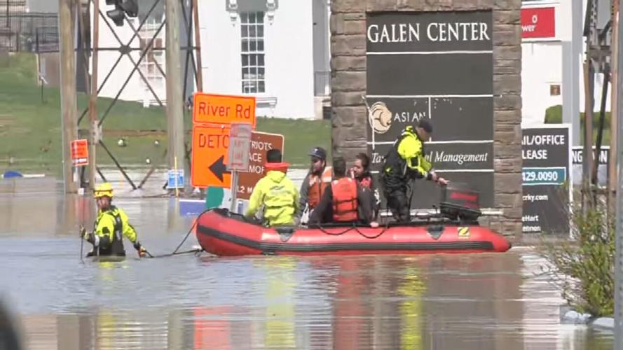
Jefferson County
- The I-71 North and South on-ramps from Zorn Avenue are closed due to flooding.
- The I-71 North off-ramp to Zorn Avenue (Exit 2) is closed due to flooding.
- CLEAR (Only right turns are permitted when taking the off-ramp due to flooding.)
- The I-71 South off-ramp to Zorn Avenue (Exit 2) is closed due to flooding.
- The I-64 West off-ramp to 3rd Street/River Road/Downtown (Exit 5B) is closed due to flooding.
Bullitt County
- KY 44 (Shepherdsville Road) is closed between mile markers 9 and 10 (near Pitts Point Road) due to high water.
- KY 1494 (Beech Grove Road) is closed between mile points 2.1 and 3.2 (near the David Arnold Memorial Bridge) due to high water.
- CLEAR: KY 480 (Cedar Grove Road) is closed between mile markers 10 and 11 (between Woodsdale Road and Grigsby Lane) due to high water.
Oldham County
- KY 3222 (Rose Island Road) is closed at Spring Drive from mile point 0.9 to mile point 1.6 due to high water.
- KY 524 (Covington Road) is closed between mile points 3.6 and 5.4 due to high water.
Franklin County
No road closures at this time.
Shelby County
No road closures at this time.
Spencer County
- KY 48 (Highgrove Road) is closed between mile points 3.3 and 4.2 (between Hickman Lane and KY 623/Lilly Pike) due to high water.
- KY 1169 (Plum Ridge Road) is closed between mile points 0.2 and 0.5 (near the KY 1060 intersection) due to high water.
- KY 652 (Little Union Road) is closed between mile points 3.5 and 4.0 (near Simpson Creek) due to high water.
- KY 623 (Lilly Pike) is closed between mile points 4.5 and 5.2 (between Love Lane, just past J T Johnson Road) due to high water.
- KY 1169 (Normandy Road) is closed between mile points 8.5 and 8.9 (between Yates Road and Yoder Tipton Road) due to high water.
- KY 2885 (Bowman Lane/West River Road) is closed between mile points 2.4 and 2.8 (near Netherton Lane) and between mile points 4.4 and 6.9 (near Bowman Road/West River Road) due to high water.
Henry County
- CLEAR: KY 202 (Drennon Road) is closed from mile point 6.8 to mile point 10.281 due to high water.
- CLEAR: KY 389 (Harpers Ferry Road/River Road) is closed between mile points 4.4 and 7.9 (near Carter Road to Bethlehem Road) and from mile marker 8 to mile marker 21 (near Gullion Branch Road).
- KY 1360 (Franklinton Road) is closed between mile points 6.6 and 6.9 (near Quickert Lane to Ky 202/Drennon Road).
Trimble County
- NEW: U.S. 421 South is down to one lane at mile point 5.3196 due to a shoulder slip.
- KY 36 is closed between mile points 0.1 and 0.3 due to high water.
- KY 1838 is closed between mile points 0.3 and 4.675 due to high water.
Updates will be posted on this webpage via the KYTC District 5 website. For the latest closures, click here.
KYTC Road Closures in District 6
Friday, April 11 | 3:35 p.m.
List of roads in District 6 impacted by high water and/or mudslides:
Please note this list only includes state routes. Flooded roads added throughout the day will be listed as NEW. Roads in which water has receded are listed below as CLEAR and will then be removed from the list during the next update.
Boone County
- Riddles Run Road (KY 2852) between Beaver Road (KY 338) (0.0 mile point) and Hathaway Road (KY 536) (2.33 mile point)
Bracken County
- KY 19 near Chaney Road (4 to 5 mile point) is down to one lane with temporary traffic signals in place due to damaged pavement.
- CLEAR: Bradford Road (KY 1109) between Johnsonville Foster Road (KY 1951) and Mary Ingles Highway (KY 8) (3.91 to 5.84 mile points)
Campbell County
- E Main Street (KY 10) at the corner of Redstone Road. (3.4 to 3.65 mile points) One lane closed in the area due to damaged pavement.
- CLEAR: Washington Trace Road and Painter Road (KY 2921) closed between Oneonta Road (KY 1566) and Mary Ingles Highway (KY 8) (0.0 mile point to 2.21 mile point)
- UPDATE: Oneonta Road (KY 1566) closed at Truesdell Road (1.0 mile point)
Carroll County
- KY 389 beginning near Green Bottoms Road to KY 55 (4.48 to 7.23 mile points)
- CLEAR: U.S. 42 from KY 55 (5.57 mile point) to the intersection of US 42/KY 36 (4.52 mile point)
- KY 36 from the intersection of KY 36/US 42 (8.12 mile point) to the Carroll/Trimble County line (0.0 mile point)
- KY 55 between the spilt to KY 389 and KY 549. (3.57 to 5.76 mile points)
- KY 467 between Harrison Street and Buffalo Creek Road (0.50 to 2.0 mile points)
- KY 389 from the Carroll/Henry County line extending to near Camp Branch Road. (0.0 to 1.5 mile point)
- Goose Creek Road (KY 1204) between KY 227 and Kendall Road (0.0 to 0.45 mile points)
- KY 2997 from just north of Woodrow Wilson Road (2.51 mile point) to KY 389 (4.25 mile point)
Gallatin County
- UPDATE: Steeles Bottom Road (KY 1992) is closed between 3.1 and 3.6 mile points.
- CLEAR: Craigs Creek Road (KY 1130) between KY 35 and Winn Road (3.7 to 4.7 mile points)
- CLEAR: No commercial vehicle traffic on KY 1039 extending over the Markland Locks and Dam (6.4 to 7.1) due to flooding in Switzerland County in Indiana.
Grant County
- No closures/traffic impacts reported at this time.
Kenton County
- CLEAR: KY 14 (Rich Road) between Hempfling Road and Cruise Creek Road (6.4 to 6.8 mile points)
- Locust Pike (KY 1930) near Locust Pike Park (1.5 to 2.5 mile point)
- UPDATE: River Road (KY 8) between Amsterdam Road (KY 371) (0.01 mile point) and Lagoon Street (3.78 mile point)
- CLEAR: River Road (KY 8) from Lagoon Street to near the Villa Hills Marina (3.78 to 1.9 mile point)
- STILL CLOSED: River Road (KY 8) between the Villa Hills Marina to Amsterdam Road (KY 371) (1.9 to 0.01 mile point) due to a mudslide.
Owen County
- KY 355 is down to one lane near Severn Creek Road (4.7 mile point) due to a slide. Temporary traffic signals and signage are now in place.
- KY 355 from Gratz to KY 227 in Worthville (6.4 to 18.9 mile point)
Pendleton County
- No closures/traffic impacts reported at this time.
Robertson County
- No closures/traffic impacts reported at this time.
Updates will be posted on the KYTC District 6 webpage, here.
Big Four Bridge closed
Monday, April 7 | 6:44 p.m.
According to Jeffersonville Police Department, The Big Four Bridge and all ramps leading to it are now closed. Please stay off the bridge and ramps until further notice. Jeffersonville Police will advise when the bridge and ramps reopen.
MSD Louisville says you can wash clothes again!
Monday, April 7 | 3:15 p.m.
MSD Louisville posted on social media, "the advisory on limiting water usage has been lifted. Normal use of washing machines, dishwashers, etc. may resume."
Louisville hotel guests evacuated as water rises outside
Monday, April 7 | 2:30 p.m.
Jody Meiman, director of Louisville Metro Emergency Services, said 61people were evacuated Monday from the Candlewood Suites at River Road and Zorn Avenue. The hotel hasn't been flooded, but all roads leading to it are impassable, so emergency responders are getting guests out of the building via boat.
Storm debris drop-off sites open in Louisville
Tuesday, April 8 | 1:34 p.m.
Metro Public Works has set up several sites to drop off tree debris across Jefferson County.
The sites opened Monday and will be open from 2-7 p.m. April 7-11 and 8 a.m. to 7 p.m. Saturday, April 12.
- Shawnee Park, 4501 W. Broadway
- Tom Sawyer Park (Enter from Tom Sawyer Dr.)
- Charlie Vettiner Park (Enter from Mary Dell Rd.)
- Highview Park (Briscoe Lane entrance)
- Fern Creek Park, 8703 Ferndale Road
- Hubbards Lane Recycling Center, 595 N. Hubbards Lane
- 535 Meriwether Ave.
- Fairdale Recycling Center, 10618 W. Manslick Road
- Public Works Yard, 10500 River Rd. (Enter from Bethany Ln.)
The free drop-off sites are available for residents only, who will be asked to provide their name and address. Only tree debris will be accepted.
Disaster hotline
Monday, April 7 | 11:32 a.m.
Teladoc Health activated a disaster hotline for communities impacted by severe storms and tornadoes. The hotline provides medical care at no costs for people who have been displaced or impacted by tornado damage, significant flooding and severe weather.
According to a news release, people can receive non-emergency medical care at no cost. Adults and children can be effectively diagnosed with cold and flu symptoms, sinus problems, respiratory infections, allergies, urinary tract infections and other illnesses. Teladoc Health can also prescribe medication and refills.
The service is free of charge.
People can access the hotline at anytime at 855-225-5032 or click here.
Kentucky Center for Performing Arts Access
Friday, April 11
The Kentucky Center for the Performing Arts building at 501 W. Main St. is not affected by the flooding, and events scheduled in Whitney Hall, the Bomhard Theater and the MeX Theater are proceeding as scheduled. However, attendees of upcoming shows should expect changes when accessing The Kentucky Center parking garage as a result of flooding along River Road.
Motorists will not be able to arrive to the Riverfront Garage via River Road and should instead use Main Street. The parking garage is still accessible at the 6th Street entrance. To access the building, guests can either use elevators located in the garage or use the front Main Street entrance. All patrons may want to allow extra time so to plan for possible traffic delays due to road closures. Street and garage parking are available south of Main Street.
For the latest updates, click here.
MSD running all its pumps to combat rising floodwaters
Monday, April 7
The Louisville Metropolitan Sewer District has all 16 of its flood pump stations running right now as the Ohio River and Beargrass Creek continue to rise in the city. MSD said in a news conference Monday morning that 55 of its 150 floodgates are now closed for what appears to be a top-10 flooding event in its history.
"Be aware of the water outside," said Dane Anderson, operations director for MSD Flood Protection. "Don't think it's safe. Stay out of the waterways. As everybody's been talking, don't go around the barricades. (There's) construction going on, (and) most of that has to do with the flooding going on. We've got crews all over the city. Be mindful of them. Drive cautiously."
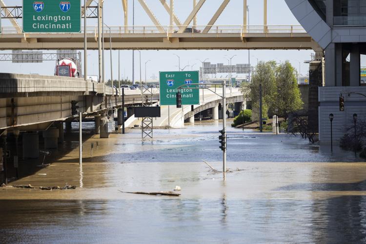
Updated Louisville road closures
Wednesday, April 9 | 9:05 a.m.
- 3rd Street/River Road/Downtown (Exit 5B) off-ramp from I-64 West
- Echo Trail is closed at 7317 Echo Trail
- Zorn Avenue from River Road to Riverwood Drive
- South Overbrook Drive from Lake Dreamland Road to end
- Blankenbaker Lane at River Hill Road
- Watson Lane at Lower River Road
- Clay Street at Franklin Street
- Indian Hills Trail from River Road to 60 Indian Hills Trail
- Mockingbird Valley Road from Mockingbird Valley Place to Mellwood Avenue
- Mockingbird Valley Road at Mockingbird Valley Green
- Mellwood Avenue at Thompson Avenue
- Indian Hills Trail from River Road to Arrowhead Road
- Fincastle Trail from Lower River Road to dead end
- Watson Lane from Lower River Road to Dixie Highway
- River Road to Zorn Avenue
- Indian Hills Trail from River Road to Rier Bluff Road
- River Road from Rockledge Road to Wolf Pen Branch Road
- East Overbrook Drive from Lake Dreamland Road to end
- Lime Kiln Road from River Knolls Drive to River Road
- Bass Road at Hays Kennedy Park entrance
- Mellwood Avenue from Zorn Avenue to Mockingbird Valley Road
- River Road from Zorn Avenue to Mockingbird Valley Road
- Mockingbird Valley Road from Mellwood Avenue to River Road
- River Road from Mockingbird Valley Road to Indian Hills Trail
- River Road from Indian Hills Trail to Blankenbaker Lane
- Riverside Drive (entire length)
- East Riverside Drive (entire length)
- West Riverside Drive (entire length)
- Riviera Drive (entire length)
- Blankenbaker Lane from River Road to Woodside Drive
- River Road from Blankenbaker Lane to Glenview Avenue
- River Road from Glenview Avenue to Lime Kiln Lane
- Mellwood Avenue to Zorn Avenue
- Mellwood Avenue from Delmont Avenue to Muncie Avenue
- River Road at Lime Kilm Lane
- River Road at Wolf Pen Branch
- River Road at Blankenbaker Lane
- Hurstbourne Parkway at Raintree Drive
- Mockingbird Valley Road (entire length)
- Hatmaker Trail (entire length)
- Mellwood Avenue from Edith Road to Zorn Avenue
- Mellwood Avenue from Brownsboro Road to Edith Road
- South Preston Street between East Jefferson Street to Market Street
- River Road from Edith Road to Zorn Avenue
- North Zorn Avenue from River Road to Mellwood Avenue
- River Road from Frankfort Avenue to Edith Road
- Edith Road from River Road to Mellwood Avenue
- Runic Way at Rustic Way between Rangland Road and Red Oak Lane
- Seatonville Road at Brush Run Road
- Mayfair Avenue from Translvania Beach Road to the first curve
- Captains Quarters Road from River Road to end
- Harbor Town Road from River Road to end (entire length)
- Juniper Beach Road from River Road to end (entire length)
- Mockingbird Valley Road from River Road to Mellwood Avenue
- Alta Vista Road from Lexington Road to Beargrass Road
- National Turnpike from Mount Holly Road to Fairdale Road
- Grade Lane from Melton Avenue to Outer Loop
- Frankfort Avenue from River Road to Story Avenue
- Campbell Street from East Water Street to Adams Street
- North Campbell Street from Adams Street to Franklin Street
- North Campbell Street from Adams Street to Geiger Street
- Lower River Road from West Orell Road to Watson Lane
- Indian Hills Trail from River Bluff Road to River Road
- Katherine Station Road from Dixie Highway to bridge
- Adams Street from Cabel Street to East Witherspoon
- Witherspoon from North Shelby Street to River Road
- Beargrass Road from Alta Vista Road to Barrett Hill Road
- West River Road from North 3rd Street to North 8th Street
- West River Road from Bingham Way to North 7th Street
- North 2nd Street from East Witherspoon Street to West River Road
- North 6th Street from West Washington Street to West River Road
- North 4th Street from West Main Street to West River Road
- North 3rd Street from West Main Street to West River Road
MSD floodwall closures
- 2nd Street
- 10th Street
- 27th Street
- Bingham Way
- Port Road
City of Frankfort extends curfew as flood levels remain in moderate stage
Wednesday, April 9 | 5 p.m.
Flood-affected areas in Frankfort have been under a mandatory curfew for the past few days as it takes a mighty blow from floodwaters as the Kentucky River spilled from its banks.
Wednesday evening, Frankfort Mayor Layne Wilkerson said in a news release that the curfew would be ongoing, starting at 8:30 p.m. through 6 a.m. nightly until it's lifted.
Areas included in the curfew are: Murray Street to the river in south Frankfort; Main Street back to Wapping in downtown; the residential area of Taylor Avenue; Bellepoint; Walter Todd Neighborhood.
Business areas in downtown Frankfort are not included in the curfew, Wilkerson said.
Police will be posted in the areas under the curfew, which Wilkerson said was put in place "to protect the residential areas impacted by flooding and to maintain public safety."
According to Wilkerson, flood levels in the city from the Kentucky River remain in the moderate flood stage at 36.6 feet.
The mayor said the flood wall saved the day once again, but wants to make sure it's safe before sending people back to their homes.
"The flood wall did hold, but it had been pressured more than it has been," Wilkerson said. "So we wanted to make sure visual inspection, having engineers look at it, make sure it was safe before we encourage people that it's safe to go back into their homes."
The flooding turned downtown city streets into lakes and a wastewater system was knocked offline. As floodwaters recede, crews from the city and Franklin County are beginning to clean streets.
Frankfort debris drop-off
Wednesday, April 9 | 7:30 p.m.
Residents are being asked not to begin cleaning debris until the streets are clean. When that time comes, Mayor Layne Wilkerson said, dumpsters will be located at the following locations across the city and county starting Thursday morning:
- Wilkinson and Wapping streets
- Watson Court
- St. Clair near Singing Bridge
- Logan and East 2nd streets
- 318 East 2nd Street
- East 3rd Street and Paul Sawyier Drive
- East 4th Street and Admirals Landing
- Second Street School
- Hawkins Drive
- Wilson and Major streets
- Benson Avenue
- Access Road off Kentucky Avenue
- Leestown Lane
The city said all cleanup debris, with the exception of tires, appliances and hazardous materials, can be put in the dumpsters. Hazardous waste can be taken to the HHW collection event next Saturday, April 19. Appliances can be left curbside for collection.
If you need assistance related to the flood, call the EOC hotline at 502-352-2252. The city set up a new hotline for those needing help with electrical reconnection for homes that sustained water damage. The hotline is open from 8 a.m. to 8 p.m. You can reach the hotline at 502-352-2280 for guidance on "safely navigating electrical inspections and reconnections with county inspectors and utility agencies."
The city has been sharing updates on its Facebook page, here.
Frankfort food distribution sites, shelters
Wednesday, April 9 | 7:30 p.m.
Water and food distribution sites have been set up throughout Frankfort. Three cases of water and 1 case of MRE (meals ready to eat) per car will be given out. Hours are 8 a.m. to 8 p.m. starting Tues., April 8 at the following locations:
- Lakeview Park, 112 Park Ave.
- Western Hills High School, 100 Doctors Dr.
- Juniper Hill Park, 800 Louisville Rd.
Additionally, there will be food and water distribution from noon to 6 p.m. daily at the former Pic Pac building on West Second Street. Citizens will also be able to drop off and pick up cleaning supplies.
The city said Wednesday there are two shelters open for residents displaced by flooding. Those include the Senior Activity Center on Medical Heights Drive and Franklin County High School on East Main Street.
Frankfort Mayor Layne Wilkerson said the shelters are working with the Red Cross and have "plenty of capacity."
Mandatory evacuations in Carrollton
Sunday, April 6
Carrollton Mayor Robb Adams originally stated that 10 floodgates at Dix Dam were accidently opened but later said that the gates were planned to release water.
There is a mandatory evacuation in Carrollton for the areas of Green's Bottom, Happy Hollow and Prestonville.
The release of water from the Herrington Lake Spillway in Mercer County was a planned release due to the level of the lake
All Kentucky state office buildings closed Monday
Sunday, April 6 | 7 p.m.
The Executive Branch closed all state office buildings on Monday, April 7 due to extreme flooding. This includes ALL driver testing offices.
Testing appointments for April 7 have been rescheduled for April 28 at the same timeslot.
Updates on roadways in Clark County
Friday, April 11 | 6:11 p.m.
Roads CLOSED due to flooding:
- Emery Crossing at McCullough Pike
- Miles Road at Haven Road
- Camp Creek Road
- Flint Ridge Road at Camp Creek Road
- Charlestown Bethlehem Road at Camp Creek Road
- Bull Creek Road at Blue Ridge Road
- Old Salem Road at 4th Street
- Upper River Road at Bridge
- South Patrol Road at Paul Garrett Avenue
- Gutford Road between Deepwood Road and Pensive Road
Clark County Sheriff Scottie Maples has been providing updated road closures on his Facebook page, here.
Release of water from Herrington Lake Spillway
Sunday, April 6 | 5:30 p.m.
The release of water from the Herrington Lake Spillway in Mercer County was a planned release due to the level of the lake, according to KYTC - District 7.
All flood prediction models have factored the release into the predicted flood models.
Sherry Sebastian, the 1st District Magistrate on the Franklin County Fiscal Court, said the water flow from Dix Dam were included in the crest protection that remains at 49.5 feet.
Utica update
Sunday, April 6 | 4:30 p.m.
At 6 p.m., Sunday the town will be restricted to the residences that live within town limits and entry will be granted to those who provide valid ID.
Traffic Control Devices have also been set up for the safety of residents and first responders.
Courts closed in Frankfort
Sunday, April 6 | 3:30 p.m.
The Supreme Court, Court of Appeals, Franklin County courts and Administrative Office of the Courts in Frankfort will be closed Monday, April 7.
The Franklin County courts will be closed all week. Gov. Andy Beshear has urged Franklin County residents to conserve water.
To check for closings and schedule changes, click here.
President Trump approves emergency declaration in Kentucky
Sunday, April 6 | 1:45 p.m.
President Donald Trump approved emergency declarations for Arkansas, Kentucky and Tennessee, which allows FEMA to identify, mobilize and provide equipment and resources to support state and local efforts. FEMA is also coordinating with the Department of Defense and other federal agencies to leverage their resources and equipment if requested by the state.
Kentucky
- Residents and visitors can visit the Kentucky Emergency Management website for the latest information.
- Urban Search and Rescue teams are currently deployed to Greenville, Louisville and Moorehead.
- FEMA Mobile Emergency Response Support assets are deployed to Frankfort and Louisville, which provide mobile telecommunications, operational support and power generators in support of response officials on the ground.
- Emergency Management Assistance Compact task forces, which enable resource sharing across states during disasters, are supporting state and local operations.
- Voluntary evacuations are in place for residents of Nelson County.
Kentucky National Guard deployed to Bullitt County
Sunday, April 6 |1 p.m.
The Kentucky National Guard has been deployed to Bullitt County in Lebanon Junction and is on standby for Shepherdsville. Other agencies are en route as well.
A majority of Lebanon Junction is without power. There are three shelters that are still operational and staffed by Red Cross. Those locations include North Bullitt High School, Roby Elementary School and Lebanon Junction Elementary School.
The Salt River is expected to crest on Monday at 2 p.m. at 37.2 feet.
Weather Forecast | Live Cams | Radar | Share Photos & Videos
City of New Albany asks residents to avoid using washers and dishwashers
Sunday, April 6 | 1 p.m.
The City of New Albany wastewater department posted on social media asking residents to reduce impact on the system through Monday. This will help reduce strain on water pump stations. You can help by limiting your large water usage appliances like dishwashers and washing machines. Direct questions and concerns to the city at 812-948-5320.
Charlestown asked to limit water usage
Sunday, April 6 | 12:30 p.m.
The City of Charlestown is requesting that residents limit water usage through Monday to help ease the stress on our wastewater utility during the heavy rainfall.
Nelson County flood relief donation drop-off
Sunday, April 6 | Noon
The Nelson County Fiscal Court is hosting a flood relief donation drop-off location at the Civic Center. The drop-off location is open Sunday through Wednesday 8 a.m. to noon and 1 p.m. to 4 p.m. Here are some of the items needed. For a complete list, go to the Fiscal Court Facebook page.
- Bleach
- Garbage bags
- Shop towels
- Paper towels
- Trash cans
- Sponges and scrub brushes
- Disinfectants
- Non-perishable shelf-stable food
- Bottled water
- Shovels and rakes
- Buckets
- Wet/dry vacuums
Caesars Southern Indiana temporarily closed
Friday, April 11 | 10:23 a.m.
Due to the rising Ohio River conditions, Caesars Southern Indiana temporarily closed Saturday, April 5. Scheduled promotions were also canceled until further notice.
Friday, April 11, Caesars said the Ohio River is receding, but they will remain closed as they work towards welcoming guests once again.
Updates, including a reopening date, will be posted on their social media.
Red Cross shelters
Saturday, April 5 | 4 p.m.
The following Red Cross and partner shelters are open in the Kentuckiana area:
Indiana:
- First Capitol Church, 305 Oliver Street, Corydon, IN 47112 (Opens at 6 p.m. Saturday)
- Salvation Army, 331 East Main Street, Madison, IN 47250
- Utica United Inc., 605 Old Salem Road, the shelter is being operated by staff and volunteers from the Clark County Health Department, but the American Red Cross will take over operations once their team and supplies arrive on site
Kentucky:
- Camp Kysoc, Camp Kysoc Road KY-36, Carrollton, KY 41008
- General Butler State Park, 1608 KY-227, Carrollton, KY 41008
- Franklin County High School, 1100 E. Main St., Frankfort, KY 40601
- Senior Activity Center, 202 Medical Heights Dr., Frankfort, KY 40601
- North Bullitt High School, 3200 E. Hebron Lane, Shepherdsville, KY 40165
- Roby Elementary School, 1148 KY-44, Shepherdsville, KY 40165
Thunder Over Louisville canceled
Saturday, April 5 | 3 p.m.
Mayor Craig Greenberg announced the cancellation of the 2025 Thunder Over Louisville. Due to the water levels, officials determined that it wouldn't be possible to reschedule or postpone the event.
But there will still be Kentucky Derby Festival events leading up to Derby Day.
Utica asking residents for information
Saturday, April 5 | Noon
The Utica Police Department said any residents who live in an expected flood area and plan to stay in their home, must inform the town.
Under FEMA requirements, the town must know who's staying. Residents are asked to call Steve Long or Curtis Wells and provide their name, address and phone information.
Steve Long can be reached at 502-767-4297 and Curtis Wells can be reached at (812) 557-3960.
An shelter has been opened for Utica residents. It's located at Utica United Inc., 605 Old Salem Road, the shelter is being operated by staff and volunteers from the Clark County Health Department, but the American Red Cross will take over operations once their team and supplies arrive on site.
More Kentuckiana Flooding Coverage:
Indiana governor declares state of disaster emergency in 18 counties due to flooding, storms
EPA launches website to keep community informed on Kentucky flood response efforts
Buffalo Trace Distillery working to reopen in ‘limited capacity’ after historic flooding
Businesses plan alternate celebrations after Thunder Over Louisville cancellation
Louisville launches $5 million citywide flood cleanup plan ahead of Kentucky Derby
Are canned goods safe after flooding? Here's what to know from Louisville health officials
'Thankful to be alive' | Jeffersontown residents cleaning up after last week's EF-3 tornado
Beshear confirms 7th flooding-related death in Kentucky
Salt River in Shepherdsville begins to recede as residents start cleaning up
Utica residents prepare for long cleanup process as floodwaters slowly recede
'Once in a lifetime' flooding in New Albany transforms Silver Creek's landscape
Louisville nonprofit helping workers of restaurants forced to close due to flooding
LMPD River Patrol uses rescue boats to survey flooded River Road
River Road remains under water due to historic flooding
Flooding inundates parts of Madison, Indiana; cleanup could 'take months'
Ohio River still rising in Louisville as mayor's focus shifts to cleanup efforts
Body of 50-year-old Lebanon Junction man pulled from floodwaters in Bullitt County
Nelson County residents hammered by floodwaters leaning on neighbors for help, rescue
Flooding persists in New Albany as waters continue to rise
Airboats used for flood rescues in southern Indiana as water reaches record levels
Frankfort's Buffalo Trace Distillery closed after 'unprecedented' flooding from Ky. River
Galt House processing refund requests after Thunder Over Louisville cancellation
Kentucky watches for surging rivers to recede so widespread cleanup can begin
West Point residents riding out Ohio River flooding put preparations to the test
Louisville firefighters rescue dozens as floodwaters rise rapidly along Ohio River
Businesses bracing for 'economic blow' from loss of Thunder Over Louisville revenue
Shelters set up in Carrollton, Kentucky, as residents leave mandatory evacuation zones
Bullitt County flooding worst since 1997 as Salt River crests near 37 feet
Ohio River flooding forces evacuations in Utica, Indiana
MSD running all its pumps to combat rising floodwaters in Louisville
Kentucky River crests dangerously close to breaching Frankfort's floodwall
Rising Ohio River floods Louisville neighborhoods, forcing evacuation
Mandatory evacuations ordered in areas of Carrollton, Kentucky, amid rising floodwaters
FEMA deploys resources to Kentucky after President Trump approves emergency declaration
Louisville slammed by snow, tornadoes and historic flooding to start 2025
Thunder Over Louisville canceled due to flooding
Marc Weinberg's exclusive look at how high floodwaters will rise across Louisville area
City officials preparing for possibility of top-10 flooding event in Louisville's history
Avoid the area: Kentucky officials ask public to stay away from West Point
Utica residents evacuate as Ohio River is set to flood dozens of southern Indiana homes
Local hardware stores see influx of customers gathering supplies to clean up after flooding
State of emergency declared in Louisville after tornado with major flooding expected
Copyright 2025 WDRB Media. All Rights Reserved.


